Heavens

COLLEGE STATION, Oct. 23, 2013 — Texas A&M University and the University of Texas at Austin may be former football rivals, but the Lone Star State's two research giants have teamed up to detect the most distant spectroscopically confirmed galaxy ever found — one created within 700 million years after the Big Bang.

The research is published in the most recent edition of the journal Nature.
Satellite data revealed that Raymond, formerly a hurricane, now a tropical storm is finally moving away from the coast of south-central Mexico.

NASA's Terra satellite captured a visible image of Raymond over Mexico on Oct. 22 at 1:50 p.m. EDT when it was still a hurricane. On Oct. 23, at 11 a.m. EDT/1500 UTC, visible imagery from NOAA's GOES-West satellite showed that Raymond had moved slightly away from the Mexican coast. The image was created by NASA's GOES Project at NASA's Goddard Space Flight Center in Greenbelt, Md.

NASA's Terra satellite flew over Lekima after it became a super-typhoon in the northwestern Pacific Ocean and captured visible and infrared data on the storm.

Early on Oct. 23 at 00:25 UTC/Oct. 22 at 8:25 p.m. EDT, the Moderate Resolution Imaging Spectroradiometer instrument that flies aboard NASA's Terra satellite was busy capturing data on Lekima. The MODIS image clearly showed Lekima's 20 nautical mile/23 mile/37 km-wide-eye with bands of thunderstorms wrapping tightly into the center of circulation.

NASA's TRMM satellite data provided forecasters at the National Hurricane Center with a good look at how wind shear is affecting Tropical Storm Lorenzo in the Atlantic Ocean.

You might think that a pair of parallel plates hanging motionless in a vacuum just a fraction of a micrometer away from each other would be like strangers passing in the night—so close but destined never to meet. Thanks to quantum mechanics, you would be wrong.

Scientists working to engineer nanoscale machines know this only too well as they have to grapple with quantum forces and all the weirdness that comes with them. These quantum forces, most notably the Casimir effect, can play havoc if you need to keep closely spaced surfaces from coming together.

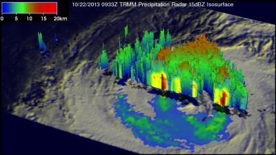
On Oct. 22, 2013 Typhoon Francisco was already affecting the southern islands Japan when the TRMM satellite had a good view of its rainfall and cloud heights.

On Oct. 23, as Typhoon Francisco moved closer to Japan's southern islands, the Daito islands and islands of Okinawa (including Kadena Air Base) and Amami-Oshima were all receiving rainfall, gusty winds and strong surf. Those islands are under warnings and facing high waves, gale-force winds, storm surge and heavy rainfall.

Supermassive black holes: every large galaxy's got one. But how did they grow so big?

A paper in the journal Science pits the front-running ideas about the growth of supermassive black holes against observational data — a limit on the strength of gravitational waves from pairs of black holes, obtained with CSIRO's 64-m Parkes radio telescope in eastern Australia.The study was jointly led by Dr Ryan Shannon, a Postdoctoral Fellow with CSIRO, and Mr Vikram Ravi, a PhD student co-supervised by the University of Melbourne (Australia) and CSIRO.

Typhoon Francisco was already spreading fringe clouds over southern Japan when NASA's Aqua satellite flew overhead and captured a picture of the storm from space.

A month ago Hurricane Manuel caused landslides and extensive flooding along Mexico's Pacific Ocean coast. Recently formed Hurricane Raymond is expected to cause heavy rainfall in nearly the same area. NASA's TRMM satellite measured the rate of heavy rainfall that Raymond was generating over the Mexican coast.

It took six hours for the thirteenth tropical depression of the Atlantic Ocean hurricane season to organize and strengthen into Tropical Storm Lorenzo. NASA's Aqua satellite captured a "before" image and NOAA's GOES satellite captured an "after" image of the depression's transition.

Tropical Storm Lekima intensified quickly early on Oct. 22 while traveling over the open waters of the Northwestern Pacific Ocean. The day before the rapid intensification, NASA's TRMM satellite passed overhead and analyzed the rainfall rates in the storm, spotting heavy rainfall in two quadrants.

As firefighters emerge from another record wildfire season in the Western United States, University of California, Berkeley, scientists say it's time to give them a 21st century tool: a fire-spotting satellite.

Such a satellite could view the Western states almost continuously, snapping pictures of the ground every few seconds in search of hot spots that could be newly ignited wildfires. Firefighting resources could then be directed to these spots in hopes of preventing the fires from growing out of control and threatening lives and property.

The twenty-eighth tropical depression of the Northwestern Pacific Ocean tropical cyclone season developed and strengthened into Tropical Storm Lekima.

On Oct. 21 at 1500 UTC/11 a.m. EDT, Tropical Storm Lekima had maximum sustained winds near 55 knots/63.2 mph/101.9 kph. It was centered near 13.6 north and 159.4 east, about 815 nautical miles/ 937.9 miles/1,509 km east of Saipan. Lekima was moving to the north-northwest at 10 knots/11.5 mph/18.5 kph.

Several of NASA's fleet of Earth-observing satellites have been gathering data on Typhoon Francisco as it moves toward Japan. NASA's Aqua, Terra and TRMM satellites captured infrared, visible and rainfall data on the super typhoon.

As Japan still recovers from Typhoon Wipha, the country is now expecting Francisco to make a brief landfall near Tokyo and parallel the country's east coast.

Low pressure System 96E developed quickly over the weekend of Oct. 19 and 20 and by Oct. 21 had grown into Hurricane Raymond. Before Raymond exploded into a major hurricane NASA's Terra satellite flew overhead from space and NOAA's GOES satellite provided images of Raymond as a major hurricane.

On Oct. 19 at 11 p.m. EDT, System 96E organized into Tropical Depression 17-E about 205 miles/330 km south of Acapulco, Mexico. By 5 a.m. EDT on Oct. 20, the depression strengthen into Tropical Storm Raymond.