The twenty-eighth tropical depression of the Northwestern Pacific Ocean tropical cyclone season developed and strengthened into Tropical Storm Lekima.
On Oct. 21 at 1500 UTC/11 a.m. EDT, Tropical Storm Lekima had maximum sustained winds near 55 knots/63.2 mph/101.9 kph. It was centered near 13.6 north and 159.4 east, about 815 nautical miles/ 937.9 miles/1,509 km east of Saipan. Lekima was moving to the north-northwest at 10 knots/11.5 mph/18.5 kph.
A visible image of Tropical Storm Lekima was obtained by Japan's MTSAT-2 satellite on Oct. 21 at 0532 UTC/1:32 a.m. EDT. Additional infrared satellite imagery showed that the tropical storm was organizing and consolidating. Imagery showed that bands of thunderstorms were wrapping around the well-defined center of circulation, and a pinhole eye-like feature.
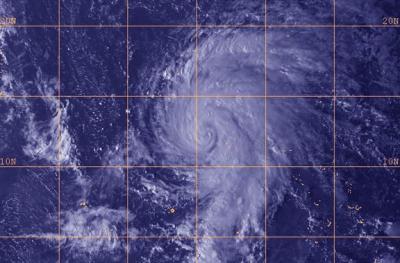
This visible image of Tropical Storm Lekima was obtained by Japan's MTSAT-2 satellite on Oct. 21 at 0532 UTC/1:32 a.m. EDT.
(Photo Credit: JAXA/NRL)
Forecasters at the Joint Typhoon Warning Center expect Lekima to strengthen to typhoon strength in the next day. Lekima's maximum sustained winds are expected to peak near 115 knots/132.3 mph/213 kph by Oct. 24 as it continues to move over open waters of the Northwestern Pacific. Lekima is forecast to approach Iwo To on Oct. 24, and then turn to the northeast away from the island.
Source: NASA/Goddard Space Flight Center