Tropical Storm Lekima intensified quickly early on Oct. 22 while traveling over the open waters of the Northwestern Pacific Ocean. The day before the rapid intensification, NASA's TRMM satellite passed overhead and analyzed the rainfall rates in the storm, spotting heavy rainfall in two quadrants.
NASA's Tropical Rainfall Measuring Mission satellite known as TRMM, is managed by NASA and the Japan Space Agency. TRMM flew over Lekima on Oct. 21 at 07:18 UTC/3:18 a.m. EDT and found the heaviest rainfall north and east of the center, falling at a rate of over 2 inches/50 mm per hour. The Joint Typhoon Warning Center noted on Oct. 22 that satellite data indicated convection (rising air that forms thunderstorms that make up the typhoon) deepened/strengthened.
On Oct. 22 at 0900 UTC/5 a.m. EDT, Lekima's maximum sustained winds were up to 105 knots/120.8 mph/194.5 kph. Lekima's center was located near 16.7 north and 156.1 east, about 705 nautical miles/ 811.3 miles/ 1,306 km east-northeast of Andersen Air Force Base, Guam. Lekima is moving to the northwest at 18 knots/20.7 mph/33.3 kph.
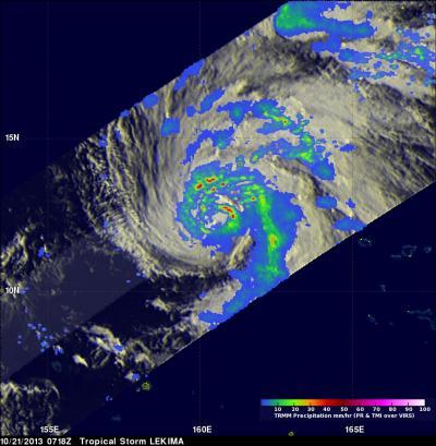
NASA's TRMM satellite analyzed the rainfall rates in Tropical Storm Lekima on Oct. 21 and found the heaviest rainfall north and east of the center (red) at over 2 inches/50 mm per hour.
(Photo Credit: Image : NASA/SSAI, Hal Pierce)
Satellite data on Oct. 22 showed that Lekima now has a well-formed eye, about 15 nautical miles/17.2 miles/27.7 km wide with tight bands of thunderstorms wrapping into it.
Lekima is forecast to continue on a northwesterly track for the next several days before making a turn to the northeast as it reaches the island of Iwo To.
Source: NASA/Goddard Space Flight Center