The fire season in California has been anything but cooperative this year. Hot conditions combined with a state-wide drought and dry lightning makes for unpleasant conditions and leads to an abundance of forest fires.
Heavens
In 2007, when talk began of using Global Hawks for Earth science, CPL was among the first sensors considered; its size is perfect for the instrument compartment. Worries about the untested Global Hawk led to a second nearly identical instrument being built for use on the unmanned aircraft. It flew on NASA's maiden Global Hawk Pacific campaign in 2009. Since then, the Global Hawk CPL has flown in two multi-year campaigns, alternating between the Airborne Tropical Tropopause Experiment (ATTREX) and HS3.
NASA's Global Hawk 872 aircraft flew over Hurricane Cristobal on August 28 and 29 and gathered data on the storm as it was becoming extra-tropical.
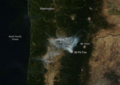
The 36 Pit Fire began on September 13, 2014. The fire is human-caused and is still under investigation. It is currently over 2,300 acres in size and is mostly being fueled by grass and timber. The 36 Pit Fire was calm Monday night due to higher humidity. Yesterday (8/15), firefighters made progress in establishing an anchor point and beginning to construct a fireline on the West and North sides of the fire.
The following resources are working on the fire:
The AIRS instrument aboard NASA's Aqua satellite uses infrared light to read cloud top temperatures in tropical cyclones. When Aqua passed over newborn Tropical Storm Polo off of Mexico's southwestern coast it got a "cold reception" when infrared data saw some very cold cloud top temperatures and strong storms within that hint at intensification.
Malvern, Pennsylvania, September 16, 2014 – Neuronetics, Inc., today announced that results of a study designed to assess the long-term effectiveness of NeuroStar TMS Therapy in adult patients with Major Depressive Disorder (MDD) who have failed to benefit from prior treatment with antidepressant medications, were published online in The Journal of Clinical Psychiatry.
NASA's Aqua satellite saw Typhoon Kalmaegi's center near northern Hainan Island, China when it passed overhead on September 16 at 06:00 UTC (2 a.m. EDT). Hours later, the storm crossed the Gulf of Tonkin, the body of water that separates Hainan Island from Vietnam, and was making landfall there at 11:30 a.m. EDT.
Building on previous research that twisted light to send data at unheard-of speeds, scientists at USC have developed a similar technique with radiowaves, reaching high speeds without some of the hassles that can go with optical systems.
The researchers, led by electrical engineering professor Alan Willner of the USC Viterbi School of Engineering, reached data transmission rates of 32 gigabits per second across 2.5 meters of free space in a basement lab at USC.
The unmanned Global Hawk aircraft that's part of NASA's airborne Hurricane and Severe Storm Sentinel, or HS3 mission was winging its way to Hurricane Edouard on September 16. In addition to the Global Hawk, various NASA satellites are continually providing data on the Atlantic hurricane.
Torrential rainfall is predicted to continue near the weakening system. Flash floods and landslides with rainfall totals of over 152-305 mm (6-12 inches) are predicted by the NHC as Odile travels over the Baja California Peninsula. Western Mexico is expected to feel the effects of Hurricane Odile today and tomorrow as the hurricane continues to hug the coast. A Hurricane Warning is in effect for Baja California Sur from Punta Abreojos to Santa Rosalia. A Hurricane Watch remains in effect for the west coast of Baja California Sur from north of Punta Abreojos to Punta Eugenia.
On Sunday morning, September 14, 2014 at 1102 UTC (7:02 a.m. EDT) NASA's Global Hawk 872 took off from NASA's Wallops Flight Facility, Virginia on a flight toward Tropical Storm Edouard for a 24 hour mission. It was the sixth science flight for the Global Hawk during the Hurricane and Severe Storms Sentinel or HS3 mission. For more information about NASA's HS3 mission, visit: http://www.nasa.gov/hs3
NASA's Aqua satellite observed Typhoon Kalmaegi crossing the South China Sea and a satellite image from the MODIS instrument aboard made it look like a whirlpool of clouds.
On Sunday, September 14, Kalmaegi passed over northern Luzon, Philippines and emerged into the South China Sea. Typhoon Kalmaegi's maximum sustained winds were near 65 knots (75 mph) making it a category one hurricane on the Saffir-Simpson scale as it moved over the Philippines.
A tiny fragment of Martian meteorite 1.3 billion years old is helping to make the case for the possibility of life on Mars, say scientists.
The finding of a 'cell-like' structure, which investigators now know once held water, came about as a result of collaboration between scientists in the UK and Greece. Their findings are published in the latest edition of the journal Astrobiology.
Two fires are seen burning in this satellite image taken by the Aqua satellite on September 11, 2014. The Selway complex of fires had been previously reported located 30 miles west of Darby, MT. It appears a new fire may have started again in this complex. Currently the size of the complex is 1,659 fires. The fire is mostly contained and there will be no additional reporting on this fire unless activity increases. It is, for the most part, contained.
BOULDER, Colo – Researchers at the University of Waterloo in Canada have directly entangled three photons in the most technologically useful state for the first time, thanks in part to superfast, super-efficient single-photon detectors developed by the National Institute of Standards and Technology (NIST).