On Sunday morning, September 14, 2014 at 1102 UTC (7:02 a.m. EDT) NASA's Global Hawk 872 took off from NASA's Wallops Flight Facility, Virginia on a flight toward Tropical Storm Edouard for a 24 hour mission. It was the sixth science flight for the Global Hawk during the Hurricane and Severe Storms Sentinel or HS3 mission. For more information about NASA's HS3 mission, visit: http://www.nasa.gov/hs3
On Sunday at 5 p.m. EDT Edouard's maximum sustained winds had increased to near 85 mph (140 mph) and additional strengthening is forecast. The National Hurricane Center (NHC) noted on Monday, September 15 at 11 a.m. EDT that Edouard's maximum sustained winds increased to 105 mph (165 kph) making it a Category 2 hurricane on the Saffir-Simpson Scale.
NHC forecaster Cangliaosi noted "Satellite images show that the eye of Edouard has become larger and more distinct during the past few hours, with a fairly symmetric inner-core convective pattern."
The center of Hurricane Edouard was near latitude 27.3 north and longitude 55.5 west. That's about 655 miles (1,055 km) east-southeast of Bermuda. Edouard was moving toward the northwest near 14 mph (22 kph) and a movement toward the north is expected on Tuesday, September 16. The estimated minimum central pressure is 966 millibars.
The NHC forecast calls for some strengthening through the end of the day on September 16 while the hurricane remains in favorable conditions. Beyond that time, cooler water, dry air, and a pronounced increase in wind shear is expected to cause Edouard to weaken steadily.
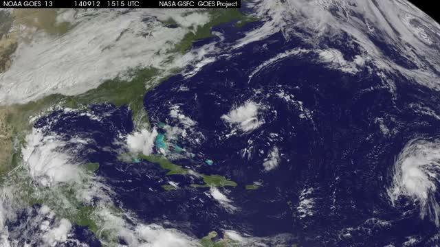
This GOES-East satellite image animation of Edouard from Sept. 13 through 15 showed the storm consolidating. The eye of the hurricane became visible on and off during Sept. 14 in between being obscured by high clouds, and the eye opened again on Sept. 15. TRT: 0:35
(Photo Credit: Image : NASA/NOAA GOES Project)
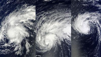
NASA's Terra satellite captured these three images of Edouard as it transitioned into a hurricane, from Sept. 12 (left) to Sept. 13 (center) and finally as a hurricane on Sept. 14 (right) in the Atlantic Ocean.
(Photo Credit: Image : NASA Goddard MODIS Rapid Response Team)
Source: NASA/Goddard Space Flight Center