As moisture from the tropics has been streaming into the Pacific Northwest by the "Pineapple Express" NASA's Global Precipitation Measurement (GPM) mission and a cadre of other satellites have been gathering data on the extreme rainfall. The continued "training" of rainfall into the area has caused flooding in the Portland, Oregon area with at least one death reported. Western Washington is also on flood alert due to the deluge.
"Riding a pumped up jet stream, a convoy of wet storms have pummeled and drenched the Pacific Northwest for the past week," said Bill Patzert, climatologist at NASA's Jet Propulsion Laboratory in Pasadena, California. "Following a couple of years of regional drought, all this rain and mountain snow has whiplashed many Washington and Oregon communities from extremely dry conditions into flooding and even landslides. Once again, the old adage, 'Great droughts end in great floods' comes to mind.'"
Patzert said that this hose of heavy moisture is originating in the far Western Pacific Ocean. Sweeping out of the tropics, meteorologists refer to these relatively narrow, moisture laden rain and snow producers as atmospheric rivers. For the U.S. West coast states, these storms supply up to 50% of their water supply. "They can be 'fast and furious' and damaging, but play a large role in sustaining our water supplies in the normally dry West," said Patzert.
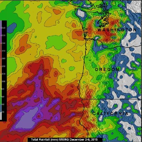
 NASA's IMERG measured rainfall from Dec. 2 to 9 and found that many areas from northern California through the state of Washington had rainfall totals greater than 160 mm (6.3 inches). Over open waters of the Pacific Ocean some rainfall totals reached over 310 mm (12.2 inches). Credit: Credits: NASA/JAXA/SSAI, Hal Pierce
Rainfall that occurred from December 2 to 9, 2015 was measured with data from NASA's Integrated Multi-satellitE Retrievals for GPM (IMERG). IMERG found that many areas from northern California through the state of Washington had rainfall totals greater than 160 mm (6.3 inches). Even more extreme rainfall was measured by IMERG over the open waters of the Pacific Ocean where rainfall totals during the past week were found to be over 310 mm (12.2 inches).
The Integrated Multi-satellitE Retrievals for GPM (IMERG) creates a merged precipitation product from the GPM constellation of satellites. These satellites include DMSPs from the U.S. Department of Defense, GCOM-W from the Japan Aerospace Exploration Agency (JAXA), Megha-Tropiques from the Centre National D'etudies Spatiales (CNES) and Indian Space Research Organization (ISRO), NOAA series from the National Oceanic and Atmospheric Administration (NOAA), Suomi-NPP from NOAA-NASA, and MetOps from the European Organization for the Exploitation of Meteorological Satellites (EUMETSAT). All of the instruments (radiometers) onboard the constellation partners are intercalibrated with information from the GPM Core Observatory's GPM Microwave Imager (GMI) and Dual-frequency Precipitation Radar (DPR).
On Dec. 9, there were a lot of watches and warnings in the region. Flood watches, warnings and flood advisories were in effect for portions of the Pacific Northwest as well as parts of northern California and northern Idaho. Winter storm watches and warnings were in effect for the Sierra Nevada Range in California and parts of the intermountain west. High wind watches, warnings and wind advisories were in effect for portions of the northwest U.S., especially in the higher terrain.
Showers and thunderstorms are in the forecast for the Pacific Northwest during the next week so rainfall totals will continue to increase.
source: NASA/Goddard Space Flight Center