On May 25, 2012 at 1500 UTC (11 a.m. EDT/U.S.), Typhoon Sanvu had maximum sustained winds near 60 knots (69 mph/111 kph), slightly weaker than it was on May 24. Typhoon-force winds cover a compact area, extending 25 miles (40 km) from the center, while tropical storm-force winds extend as far as 150 miles (241.4 km) from the center, making the storm over 300 miles (~483 km) in diameter.
Sanvu's center was located near 23.9 North and 140.3 East, only 100 nautical miles (115 miles/185 km) southwest of Iwo To, Japan and moving to the north-northeast at 7 knots (8 mph/13 kph). Sanvu continues to churn up rough seas, and the Joint Typhoon Warning Center reported that wave heights in the region are as high as 31 feet (9.4 meters).
Another instrument on NASA's Aqua satellite captured a stunning view of Typhoon Sanvu that clearly showed an eye. The image was taken on May 25 at 0355 UTC from the Moderate Resolution Imaging Spectroradiometer (MODIS) instrument onboard Aqua.

This animation of Typhoon Sanvu was created from 3-D images of TRMM satellite data during the week of May 21, 2012, as the storm moved through the western North Pacific Ocean. This video takes the TRMM data, which shows rainfall intensity within Sanvu, and applies additional processing. While there is no scientific value to this processing, it does result in a new way of looking at the data.
(Photo Credit: NASA's Goddard Space Flight Center)
Iwo To and Chichi Jima will continue to experience rough surf, showers, thunderstorms and gusty winds today, as well as on Saturday, May 26. On May 25 at 11 a.m. U.S. Eastern Time, Iwo To was experiencing thunderstorms and winds from the east between 40 to 55 mph (64 to 88.5 kph). Winds are expected to shift to the north as Sanvu continues moving by. Rainfall of up to 2 inches (50 mm) is expected on the island with more on May 26.
Forecasters at the Joint Typhoon Warning Center noted that Sanvu has likely reached its maximum intensity and will hold there before starting to weaken early on May 26 (U.S. Eastern Time). Once Sanvu gets up to 25 degrees North latitude, the ocean surface temperatures are much cooler, and will weaken the storm. A tropical cyclone needs a sea surface temperature of 80F/26.6C to maintain intensity. On May 25, Sanvu is located in an area where sea surface temperatures are around 27 Celsius (80.6F), and temperatures where it is headed are as cold as 23 Celsius (73.4F).
In addition to the cooler ocean temperatures, wind shear is expected to kick up over the next couple of days and will help weaken the storm. By the end of the weekend, Sanvu is expected to transition to an extra-tropical low pressure area in the Northern Pacific Ocean.
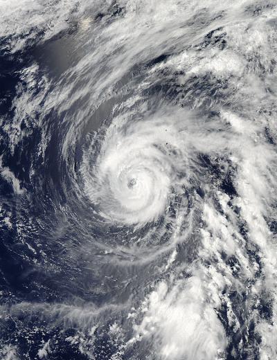
Another instrument on NASA's Aqua satellite captured a stunning view of Typhoon Sanvu that clearly showed an eye. The image was taken on May 25 at 0355 UTC from the Moderate Resolution Imaging Spectroradiometer (MODIS) instrument onboard Aqua.
(Photo Credit: NASA Goddard's MODIS Rapid Response Team)
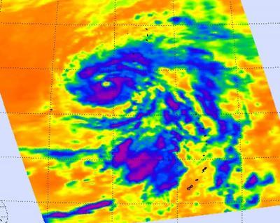
Infrared imagery from NASA's Atmospheric Infrared Sounder (AIRS) instrument onboard NASA's Aqua satellite was taken on May 25 at 0353 UTC (May 24, 1153 p.m. EDT) shows a large area of high, cold cloud tops around Sanvu's eye. The strongest storms appear in purple, south of the eye, and in a band to the north of the eye and have a cloud top temperature colder than -63F (-52C).
(Photo Credit: NASA/JPL, Ed Olsen)
Source: NASA/Goddard Space Flight Center