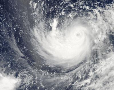
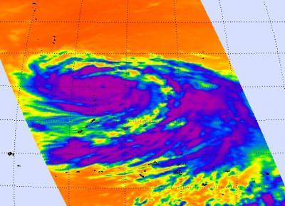
The eye of a tropical cyclone is an indication of a strong storm, and Typhoon Ma-on's eye was apparent in visible and infrared imagery captured by NASA's Aqua satellite. Ma-on just achieved Category Four status on the Saffir-Simpson scale that measures hurricane intensity.
The Moderate Resolution Imaging Spectroradiometer (MODIS) instrument that flies aboard NASA's Aqua satellite took an image of Typhoon Ma-on that clearly shows the storm's eye, although it has some high clouds in it. The image was taken at 04:15 UTC (12:15 a.m. EDT) on July 15 as Typhoon Ma-on continues moving west in the western Pacific Ocean.
When NASA's Aqua satellite passed over Ma-on on July 14 at 03:23 UTC, the Atmospheric Infrared Sounder (AIRS) instrument captured an infrared image of the storm. The infrared image showed a large area of coldest cloud tops and the strongest thunderstorms mostly south of the center of circulation, and also revealed an eye at that time.

This image of Typhoon Ma-on from the MODIS instrument aboard NASA's Aqua satellite clearly shows the storm's eye, although it has some high clouds in it. The image was taken at 04:15 UTC (12:15 a.m. EDT) on July 15 as Typhoon Ma-on continues moving west in the western Pacific Ocean.
(Photo Credit: : NASA Goddard/MODIS Rapid Response Team, Jeff Schmaltz)
On July 15 at 0900 UTC (5 a.m. EDT), Typhoon Ma-on's winds were stronger than they were the day before. Maximum sustained winds are now at 115 knots (132 mph/213 kmh). Ma-on is located about 250 nautical miles south of Iwo To, Japan near 20.7 North and 140.9 East.
The strongest thunderstorms in Ma-on are still located south of the center of circulation. Visible, microwave and infrared imagery all show a well-defined eye within the storm.
Ma-on is moving to the west-northwest along the southern edge of a subtropical ridge (elongated area) of high pressure. This weekend people on Iwo To, Chici Jima and Kadena Air Base can experience rough seas and gusty winds and rains.
Ma-on is then expected to move to the north, then northeast as it curves around the western edge of the ridge. That would put Ma-on on track to skirt the eastern edge of the big island of Japan early next week.

NASA's Aqua satellite passed over Ma-on on July 14 at 03:23 UTC and captured an infrared image of the storm, identifying the coldest cloud tops, and the strongest thunderstorms (in purple). The infrared image also revealed an eye.
(Photo Credit: NASA/JPL, Ed Olsen)
Source: NASA/Goddard Space Flight Center