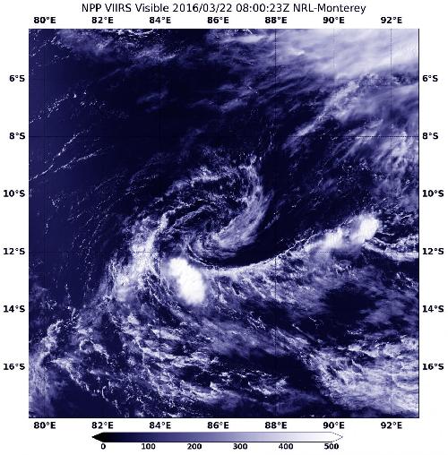
Tropical Cyclone Emeraude was pummeled by northeasterly wind shear that weakened the storm into a depression by March 22, 2016 before the Suomi NPP satellite passed overhead.
The Visible Infrared Imaging Radiometer Suite (VIIRS) instrument aboard NASA-NOAA's Suomi NPP satellite captured a visible image of the depression at 0800 UTC (4 a.m. EDT), that looked more like a swirl of clouds with an isolated burst of thunderstorms southwest of the center.
The Joint Typhoon Warning Center issued their final bulletin on Emeraude on March 22, 2016 at 0900 UTC (5 a.m. EDT) when its winds had dropped to 30 knots (34.5 mph/55.5 kph). It was located about 846 nautical miles (973.6 miles/1,567 km) east-southeast of Diego Garcia near 11.1 degrees south latitude and 86.2 degrees east longitude. It was crawling to the northwest at 1 knot (1.1 mph/1.8 kph).
 NASA-NOAA's Suomi NPP satellite captured a visible image of the remnant swirl of former Tropical Cyclone Emeraude on Mar. 22, 2016 at 0800 UTC (4 a.m. EDT) in the Southern Indian Ocean. Credit: Credits: NOAA/NASA/NRL
As northeasterly vertical wind shear continues to batter the tropical low pressure area, it no longer meets the criteria for a tropical cyclone. However, in three days environmental conditions are forecast to become more favorable, so there is a possibility that the system could regenerate. The JTWC will keep a close watch on Emeraude for possible regeneration.
source: NASA/Goddard Space Flight Center