Tropical Depression 26W was spinning down and speeding up as it was becoming an extra-tropical storm. In fact, its sustained winds were weaker than its forward speed as it moved through the western North Pacific Ocean.
On October 22 at 2100 UTC (5 p.m. EDT), the Joint Typhoon Warning Center issued its final bulletin on Tropical Depression 26. At that time it was becoming an extra-tropical cyclone.
It was located near 29.1 degrees north latitude and 157.8 east longitude, about 759 nautical miles (873 miles/1,406 km) northwest of Wake Island. 26W had maximum sustained winds near 25 knots (28.7 mph/46.3 kph) and it was weakening. It was moving to the northeast at 26 knots (29.9 mph/48.1 kph).
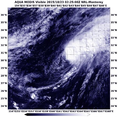
 On Oct. 23 at 0225 UTC the MODIS instrument aboard NASA's Aqua satellite showed evidence of wind shear in 26W as the bulk of clouds were pushed to the northeast of the center. Credit: Credits: NRL/NASA
The Moderate Resolution Imaging Spectroradiometer or MODIS instrument aboard NASA's Aqua satellite captured a visible image of extra-tropical cyclone 26W on October 23 at 0225 UTC (Oct. 22 at 10:25 p.m. EDT). The MODIS image showed evidence of wind shear as the bulk of clouds were pushed to the northeast of the center and the tropical depression had become an extra-tropical cyclone.
When a tropical cyclone becomes extra-tropical it has lost its "tropical" characteristics. According to the National Oceanic and Atmospheric Administration, the term "extra-tropical" implies both poleward displacement (it moves closer to the north or south pole depending on what hemisphere it is located in) of the cyclone and the conversion of the cyclone's primary energy source from the release of latent heat of condensation to baroclinic (the temperature contrast between warm and cold air masses) processes. It is important to note that cyclones can become extra-tropical and still retain winds of hurricane or tropical storm force.
The Joint Typhoon Warning Center expects extra-tropical 26W to continue moving over the open waters of the western North Pacific Ocean and continue weakening until dissipation.
source: NASA/Goddard Space Flight Center