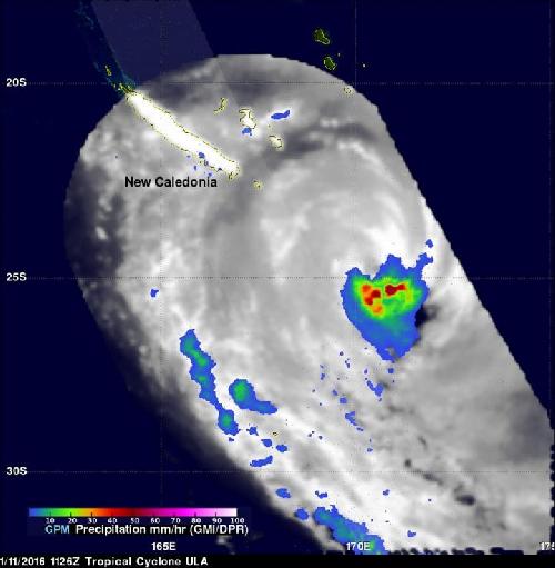
A weaker Tropical Storm Ula continued to move through the Southern Pacific Ocean on Jan. 11 after peaking at major hurricane status. NASA's RapidScat instrument looked at Ula's winds, while the Global Precipitation Measurement or GPM mission satellite measured rainfall in the storm.
Tropical cyclone Ula's winds peaked at 115 knots (132 mph) over the weekend of Jan. 9 and 10 Those high winds meant that for a couple days Ula was a category four tropical cyclone on the Saffir-Simpson Hurricane Wind Scale. Ula moved over the waters of the North Fiji Basin between the Fiji Islands and New Caledonia before moving southeastward into the South Fiji Basin.
The GPM core observatory satellite is co-managed by NASA and the Japan Aerospace Exploration Agency. GPM had good views of powerful tropical cyclone Ula during its changes in intensity. On January 8, 2015 at 2216 UTC (5:16 p.m. EST) GPM saw that rain was falling at a rate of over 63.5 mm (2.5 inches) per hour north of the intensifying tropical cyclone's eye. GPM's Dual-Frequency Precipitation Radar (DPR) instrument (Ku Band) collected 3-D data at that time that showed cloud tops reached heights above 12.2 km (7.6 miles) in Ula's inner and outer eye walls.
 GPM measured Ula's rainfall on Jan. 11, 2016 at 1126 UTC (6:26 a.m. EST). GPM's Microwave Imager (GMI) revealed that heavy rain was falling around Ula's eye. Credit: Credits: NASA/JAXA/SSAI, Hal Pierce
GPM also saw Ula on January 9 at 1136 UTC (6:36 a.m. EST) and on January 11 at 1126 UTC (6:26 a.m. EST). GPM's Microwave Imager (GMI) revealed that heavy rain was falling around Ula's eye on both dates.
On Jan. 11 at 1300 UTC (8 a.m. EST) NASA's RapidScat instrument measured surface winds in Tropical Cyclone Ula and saw strongest sustained winds near 32 meters per second//71.5 mph/115.2 kph circled the storm's center and extended south of the center.
Maximum sustained winds are not always equally distributed in a hurricane or tropical storm, and the RapidScat instrument helps forecasters find the strongest quadrants of a storm. RapidScat is an instrument that flies aboard the International Space Station.
By Jan. 12 at 0900 UTC (4 a.m. EST) Tropical Cyclone Ula's maximum sustained winds dropped to 50 knots (57.5 mph/92.6 kph). It was centered near 28.3 degrees south latitude and 172.7 degrees east longitude, about 259 nautical miles (298 miles/479.7 km) northeast of Kingston Island. Ula was moving to the southeast at 13 knots (14.9 mph/24.0 kph).
The Joint Typhoon Warning Center (JTWC) predicts that Ula will continue weakening as it becomes extra-tropical and passes over the open waters of the South Pacific Ocean well to the north New Zealand.
source: NASA/Goddard Space Flight Center