After dropping rainfall that brought a number of casualties to the central and southern Philippines, the tropical cyclone known as Lingling, and locally as Agaton in the Philippines has finally wound down.
The Joint Typhoon Warning Center issued their final bulletin on Tropical Cyclone Lingling on Monday, January 20. On that day, Lingling's maximum sustained winds were down to 25 knots/28.7 mph/46.3 kph. At 2100 UTC/4 p.m. EST, Lingling was near 6.3 north and 128.8 east, about 344 nautical miles/395.9 miles/ 637.1 km west of Koror. Lingling was moving to the south-southeast at 6 knots/6.9 mph/11.1 kph.
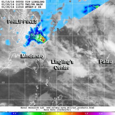
The Joint Typhoon Warning Center or JTWC combined data from two satellites to create a composite satellite image of Lingling on January 20 at 11:27 UTC/6:27 a.m. EST. JTWC used data from the Tropical Rainfall Measuring satellite called TRMM and the Japan Meteorological Agency's MTSAT-2 satellite. The image combined rainfall from TRMM, and clouds from MTSAT-2's infrared instrument. Despite Lingling's center being west of Palau and east of Mindanao, Philippines and over the waters of the Northwestern Pacific, heavy rain was occurring in Luzon and Visayas, far northwest of Lingling's center of circulation. That rainfall, however was not associated with Lingling, but a northeastern monsoon.

Data from the TRMM and MTSAT-2 satellites were combined create a composite satellite image of Lingling on Jan. 20 at 11:27 UTC. The rainfall over the Philippines is not associated with Lingling.
(Photo Credit: Image : JTWC/NRL)
Vertical wind shear stretched the storm out, further weakening its circulation and pushed the convection and showers associated with the tropical cyclone to the northwest of the storm's center. By January 21, Lingling was a remnant low pressure area.
Source: NASA/Goddard Space Flight Center