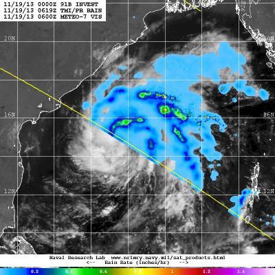
The fourth tropical cyclone of the Northern Indian Ocean season formed and is headed for landfall in a couple of days in southeastern India. NASA's TRMM satellite saw broken bands of thunderstorms with moderate rainfall in the northern and eastern quadrants of Tropical Cyclone 04B on Nov. 19.
Tropical Cyclone 04B was located just 180 nautical miles south-southeast of Visakhapatnam, India near 15.0 north and 84.5 east at 1500 UTC/10 a.m. EST on Nov. 19. 04B had maximum sustained winds near 35 knots/40 mph/64 kph and is moving to the west at 8 knots/9.2 mph/14.8 kph.
Satellite imagery showed that the low-level center is organized and there is convection (building thunderstorms) flaring around the storm's center and there is broken bands of thunderstorms around the northern quadrant of the storm. TRMM satellite data showed rainfall rates were as high as 1.2 inches/30.4 mm per hour.

NASA's TRMM satellite saw broken bands of thunderstorms with moderate rainfall (yellow, orange) in the northern and eastern quadrants of Tropical Cyclone 04B on Nov. 19, 2013 in this image overlaid on ESA's METEO-7 Satellite.
(Photo Credit: Image : NRL/NASA/ESA)
A microwave image from Nov. 19 at 1058 UTC/5:58 a.m. EST showed that the cyclone is well-defined and has curved bands of thunderstorms along the western quadrant.
The Joint Typhoon Warning Center or JTWC expects 04B to track slowly west slowly intensify before making landfall in India as a tropical storm. The JTWC expects landfall between Ongole south to Nellore, both cities in the southern India state of Andhra Pradesh late on Nov. 21.
Source: NASA/Goddard Space Flight Center