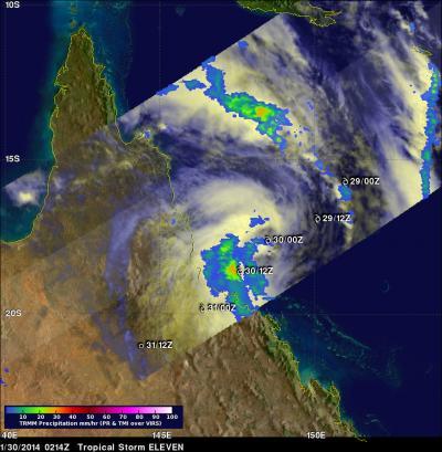
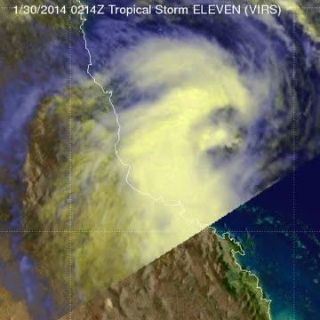
As Tropical Storm Dylan was making landfall in Queensland on January 30, NASA's TRMM satellite was capturing rainfall data on the storm.
Tropical storm Dylan was heading from the Coral Sea toward Australia's Queensland coast when it was viewed by the Tropical Rainfall Measuring Mission (TRMM) satellite on January 30, 2014 at 0214 UTC/Jan. 29 at 9:14 a.m. EST. A rainfall analysis was done at NASA's Goddard Space Flight Center in Greenbelt, Maryland using data collected by TRMM's Microwave Imager (TMI) and Precipitation Radar (PR) instruments. Rainfall rates were overlaid on an enhanced visible/infrared image from TRMM's Visible and InfraRed Scanner (VIRS) to complete the analysis. TRMM's TMI data revealed that moderate to heavy rainfall falling at the rate of over 31 mm/1.2 inches per hour was preceding Dylan's movement toward the Australian coast.
On January 31 at 0300 UTC/Jan. 30 at 10 p.m. EST, the Joint Typhoon Warning Center issued its final bulletin on Tropical Cyclone Dylan. By that time, Dylan had made landfall and was moving inland. It was centered about 178 nautical miles/204.8 miles/329.7 km southeast of Cairns, Australia near 21.3 south and 147.9 east. Dylan had maximum sustained winds near 40 knots/46 mph/74.0 kph and was quickly weakening and dissipating as it tracked over land.
At 8:02 a.m. EST on Friday, January 31, the Australian Bureau of Meteorology or ABM noted that ex-Tropical Cyclone Dylan continued moving south after crossing the coast east of Bowen early that morning. ABM warned residents from Bowen south to expect heavy rainfall from the dissipating low pressure system. ABM also noted that river rises were no longer expected from Dylan's rainfall in the Herbert, Ross, Bohle, Black and Burdekin Rivers and Bluewater Creek.

On Jan. 30 at 0214 UTC the TRMM satellite saw moderate (green) to heavy rainfall (red) falling at the rate of over 31 mm/1.2 inches per hour was preceding Dylan's movement toward the Australian coast.
(Photo Credit: SSAI/NASA, Hal Pierce)

This animation blends in moderate (green) and light (blue) rainfall rates within Tropical Cyclone Dylan as it was making landfall in Queensland on Jan. 30.
(Photo Credit: SSAI/NASA, Hal Pierce)
Source: NASA/Goddard Space Flight Center