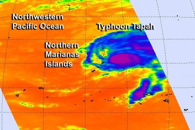
Tropical Storm Tapah strengthened since April 28 and early on April 29, the storm reached typhoon strength. From its orbit in space, NASA's Aqua satellite zoomed over Tapah and the AIRS instrument captured infrared data on the storm that showed the location of its strongest thunderstorms.
The U.S. National Weather Service in Guam noted that a tropical storm warning and a typhoon watch continues for Alamagan and Pagan. For details on the advisory, visit: http://www.prh.noaa.gov/data/GUM/HLSPQ1
The Atmospheric Infrared Sounder (AIRS) instrument that flies aboard NASA's Aqua satellite collected infrared data on Typhoon Tapah on April 29 at 03:47 UTC (April 28 at 11:47 p.m. EDT). A false-colored image was created at NASA's Jet Propulsion Laboratory (JPL) in Pasadena, Calif. showing the temperature data gathered by AIRS. The data showed that there were strong thunderstorms with cold cloud-top temperatures near -63F/-52C around the center of Tapah's circulation and to the east of the center where bands of thunderstorms were wrapping into the center.

NASA's Aqua satellite passed over Typhoon Tapah on April 29 at 03:47 UTC and saw strong thunderstorms with cold cloud-top temperatures near -63F/-52C (purple) around the center of circulation and east of the center.
(Photo Credit: Image : NASA JPL, Ed Olsen)
The Joint Typhoon Warning Center also looked at animated enhanced infrared satellite imagery and a microwave image and both showed that the convection (rising air that forms the thunderstorms that make up the tropical cyclone) had weakened slightly during the morning hours (Eastern Daylight Time/U.S.) of April 29. Both sets of data confirmed the AIRS data and also showed bands of thunderstorms remained tightly wrapped into the low level center.
Tapah reached typhoon strength today, April 29, when maximum sustained winds were near 65 knots (75 mph/120 kph). At 1500 UTC/11 a.m. EDT, Typhoon Tapah was centered near 17.6 north latitude and 147.2 east longitude, about 151 nautical miles (173.8 miles/279.7 km) northeast of Saipan. Tapah has tracked northward at 8 knots (9.2 mph/14.8 kph).
Tapah is expected to continue on a northwesterly path for a couple days until turning to the northeast around a subtropical ridge (elongated area) of high pressure. Tapah is expected to weaken and curve northeast before reaching Iwo To. The Joint Typhoon Warning Center expects Tapah to move into cooler waters and an area of increasing vertical wind shear over the next couple of days which are expected to weaken the storm quickly after a couple of days.
Source: NASA/Goddard Space Flight Center