Some satellite images are striking and memorable, while others are just interesting. On June 10, NASA's Aqua satellite flew over Hurricane Adrian from space and sent a stunning image to the science team at NASA's Goddard Space Flight Center in Greenbelt, Md. Meanwhile a GOES-11 Satellite animation shows how and when Adrian fizzled.
Adrian is no more in the Eastern Pacific as of June 13, 2011, but the Aqua satellite image it left behind will be remembered this hurricane season.
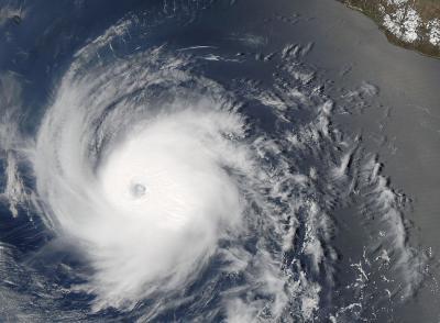
The visible image was taken by the Moderate Resolution Imaging Spectroradiometer (MODIS) that flies aboard NASA's Aqua (and Terra) satellite on June 10 at 20:10 UTC (4:10 p.m. EDT). The image shows a rounded-pinwheel shaped Adrian with a very visible eye. High, strong thunderstorms in the center of the image cast shadows on the lower thunderclouds around the eye. The bright white color of Hurricane Adrian in contrast to the blue waters of the Eastern Pacific Ocean provide a stunning image.
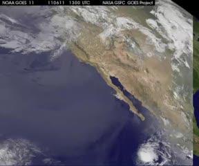
The Geostationary Operational Environmental Satellite, GOES-11, operated by NOAA watched Adrian this weekend as it faded in the Eastern Pacific. GOES-11 data was compiled into an animation by the NASA GOES Project at NASA Goddard that shows the end of Adrian. The animation runs from June 11 at 1300 UTC (9 a.m. EDT) to June 13 at 1300 UTC (9:00 a.m. EDT) and by that end time, Adrian had faded.
On Saturday, June 11 when the GOES-11 animation began, Adrian was still a hurricane with maximum sustained winds near 75 knots (86 mph/~139 kmh) . It was centered near 15.8 North and 110.5 West in the Eastern Pacific with a minimum central pressure of 979 millibars. By mid-day, Adrian had weakened to a tropical storm with maximum sustained winds near 60 knots.
By Sunday, June 12 at 1545 UTC (11:45 a.m. EDT) Adrian had weakened to remnant low pressure area status. It was located near 16.5 North and 115.8 West. The remnant low had a minimum central pressure estimated to be near 1004 millibars. It was moving west-northwest near 10 knots ~11 mph/~18 kmh) and had maximum sustained winds between 20 and 30 knots (23 and 34 mph/37 and 55 kmh).
The National Hurricane Center described Adrian's remnants mid-day Sunday (EDT) as "a tight swirl of low level clouds with scattered moderate convection flaring within 120 nautical miles over the northeastern semicircle of the center." The low is dissipating today, June 13.

The MODIS instrument aboard NASA's Aqua satellite revealed a rounded-pinwheel shaped Hurricane Adrian with a very visible eye on June 10 at 20:10 UTC (4:10 p.m. EDT).
(Photo Credit: NASA Goddard MODIS Rapid Response Team)

GOES-11 data was compiled into an animation by the NASA GOES Project at NASA Goddard that shows the end of Adrian. The animation runs from June 11 at 1300 UTC (9 a.m. EDT) to June 13 at 1300 UTC (9:00 a.m. EDT) and by that end time, Adrian has faded.
(Photo Credit: NASA/NOAA GOES Project, NASA Goddard Space Flight Center)
Source: NASA/Goddard Space Flight Center