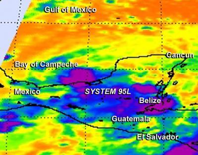
NASA's Aqua satellite passed over a developing low pressure area in the southwestern Gulf of Mexico and captured infrared data on what is now the latest destination for NASA's Hurricane and Severe Storms Sentinel mission. On Sept. 19, NASA's HS3 mission sent an unmanned Global Hawk aircraft to investigate and gather data from low pressure System 95L, located in the Bay of Campeche.
On Sept. 19 at 07:35 UTC/3:35 a.m. EDT, NASA's Aqua satellite passed over System 95L and the Atmospheric Infrared Sounder instrument or AIRS instrument that flies aboard it captured infrared data on the developing low. AIRS infrared imagery showed cold cloud top temperatures, indicating strong convection (rising air that cause thunderstorm development). Some of the strongest cloud top temperatures were near -63F/-52C. Those coldest cloud tops and strongest thunderstorms were scattered over the Yucatan Peninsula, the southern Bay of Campeche, the extreme northwestern Caribbean Sea and over the coast of Belize.
On Thursday, Sept. 19 at 8:10 a.m. EDT, NASA's Global Hawk 872 departed from Runway 10 at NASA's Wallops Flight Facility, Wallops Island, Va. NASA's Global Hawk 872 carries the environmental payload of instruments that include the CPL or Cloud Physics Lidar, S-HIS or Scanning High-Resolution Interferometer Sounder Instrument, and NOAA's AVAPS dropsonde system.

NASA's AIRS instrument captured this infrared look at developing System 95L on Sept. 19 at 3:35 a.m. EDT. Strongest thunderstorms were scattered over the Yucatan Peninsula, the southern Bay of Campeche, the extreme northwestern Caribbean Sea, and the coast of Belize.
(Photo Credit: NASA JPL, Ed Olsen)
System 95L was producing disorganized shower and thunderstorm activity during the morning of Sept. 19. The National Hurricane Center noted that conditions still appear conducive for the formation of a tropical depression during the next day or two. System 95L has a high chance of becoming a tropical depression in the next day as it moves west-northwestward to northwestward at 5 to 10 mph. The low pressure area is expected to spread heavy rain over portions of eastern and southern Mexico drenching areas already soaked by Hurricane Ingrid.
Source: NASA/Goddard Space Flight Center