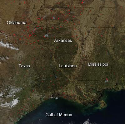
According to the Southern Area Coordination Center, which monitors and coordinates response to incidents throughout the Southeast, there are currently seven large fires burning in this area of the country. Six of them are located in the state of Oklahoma and the seventh is in the Gulf area of Louisiana. These fires currently have burned over 7,600 acres. The majority of the fires on this image, though, are not wildfires, but are prescribed fires. The Chicasaw Journal of Mississippi wrote this regarding prescribed fires: "Prescribed fire, also known as controlled burning, refers to the controlled use of fire by a team of experts to safely reduce excessive amounts of grass and brush. Prescribed fire helps reduce the catastrophic damage of wildfire on our lands and surrounding communities. Pre-planned prescribed burns are carefully analyzed and conducted under specific weather conditions.
"Prescribed fire plays an integral part in reducing fuels, improving all wildlife habitat, controlling competing vegetation, controlling disease and improving forage," said Danny Bryant, Fire Management Officer with the National Forests in Mississippi. Plants and animals native to pine habitats depend on natural fire cycles, which are mimicked through the use of prescribed fires to balance habitat and food sources. Prescribed burning is also one of the most effective land management tools used in preventing the outbreak and spread of wildfires."
Prescribed fires set by many land managment agencies across the Southeast set last week affected 94,471 acres. Year-to-date acres affected by prescribed fires in the Southeast are 526,318. The majority of prescribed fires this year have been in the Southeast most probably due to the fact that it encompasses so many states and land area, and also because the Southeast and the West seem to be the areas most affected by wildfire due to climate and area conditions which are conducive to the outbreak of wildfires.

According to the Southern Area Coordination Center, which monitors and coordinates response to incidents throughout the Southeast, there are currently seven large fires burning in this area of the country. Six of them are located in the state of Oklahoma and the seventh is in the Gulf area of Louisiana. These fires currently have burned over 7,600 acres. The majority of the fires on this image, though, are not wildfires, but are prescribed fires.
(Photo Credit: NASA's Aqua satellite collected this natural-color image with the Moderate Resolution Imaging Spectroradiometer, MODIS, instrument on March 13, 2014. Actively burning areas, detected by MODIS's thermal bands, are outlined in red. NASA image courtesy Jeff Schmaltz LANCE/EOSDIS MODIS Rapid Response Team, GSFC. Caption by Lynn Jenner)
NASA's Aqua satellite collected this natural-color image with the Moderate Resolution Imaging Spectroradiometer, MODIS, instrument on March 13, 2014. Actively burning areas, detected by MODIS's thermal bands, are outlined in red. NASA image courtesy Jeff Schmaltz LANCE/EOSDIS MODIS Rapid Response Team, GSFC. Caption by Lynn Jenner
Source: NASA/Goddard Space Flight Center