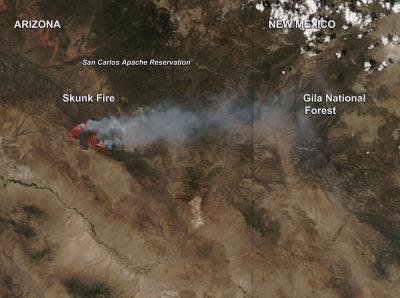
The Skunk Fire continues to burn on the San Carlos Apache Reservation in southeastern Arizona and NASA's Aqua satellite captured an image of the smoke on May 17 at 20:15 UTC (4:15 p.m. EDT/1:15 p.m. MST). A Fire Weather Watch has been posted for the region for May 20.
The Moderate Resolution Imaging Spectroradiometer or MODIS instrument that flies aboard NASA's Aqua satellite captured this photograph of the smoke. The extent of the fire (the heat) is outlined in red in this image).
According to Inciweb, the multi-U.S. agency Incident Information System website that monitors fires in the U.S., the Skunk Fire increased to an estimate of 23,642 acres as of May 18. The fire continues to spread in a northwesterly direction along Nantac Rim and to the east in Division Zulu passing Soldier Hole. Reports indicate that the fire has stopped spreading to the south in the Ash Creek area.

The Skunk Fire continues to burn on the San Carlos Apache Reservation in southeastern Arizona.
(Photo Credit: NASA image courtesy Jeff Schmaltz LANCE/EOSDIS MODIS Rapid Response Team)
On May 19 the National Weather Service issued a fire weather watch for the region for Tuesday (May 20) morning through evening. The fire weather watch calls for strong winds, low relative humidity and very high fire danger for southern Gila county and the Tonto National Forest foothills including areas around Globe, Miami, the San Carlos Reservation and mountains surrounding Roosevelt Lake.
Source: NASA/Goddard Space Flight Center