Dropping the instruments
Between Jan. 26 and Feb. 9, working day and night, watch-on and watch-off, the Thompson laid down 80 ocean bottom seismometers and five hydrophones.
The hydrophones, which detect pressure waves and convert them into electrical signals, provide less information than the seismometers, which register ground motion, but they can be tethered four miles deep in the water column where the bottom is so far down seismometers would implode as they sank.
The Thompson sailed over some of the most famous real estate in the world, the Mariana trench, which includes the bathtub-shaped depression called the Challenger Deep,
to which Avatar director James Cameron plans to plunge in a purpose-built one-man submersible called the Deep Challenger.
Seven miles down, the pressure in the Deep is 1,000 atmospheres (1,000 times the pressure at sea level on dry land) or roughly 8 tons per square inch. Seismometers, says Wiens, only go down four miles.
The trench is created by the subduction of some of the world's oldest oceanic crust, which plunges underneath the Mariana Isalnds so steeply at places that it is going almost straight down.
The active survey
After the Thompson returned to Guam and Wiens flew back to St. Louis to resume his less romantic duties as chair of the Department of Earth and Planetary Sciences, the research vessel Marcus G. Langseth began to sail transects above the matrix of seismometers, firing the 36-airgun array on its back deck.
The sound blasts reflected from the boundaries between rock layers a few miles beneath the ocean floor were picked up by an five-mile-long "streamer," or hose containing many hydrophones, towed just beneath the surface behind the ship.

Seismologists have just returned from a cruise in the Western Pacific to lay the instruments for a seismic survey that will follow the water chemically bound to or trapped in the down-diving Pacific Plate at the Mariana trench, the deep trench to which Avatar director James Cameron is poised to plunge. This video combines an interview of co-PI Doug Wiens of Washington University in St. Louis and the videos he took on the cruise.
(Photo Credit: Doug Wiens/Clark Bowen/WUSTL)
This was the "active" stage of a seismic survey with a "passive" stage yet to come.
After the seismic survey, the Langseth returned to pick up 60 seismometers, leaving behind 20 broadband seismometers and the hydrophones that will listen for a year to the reverberations from distant earthquakes, allowing the seismologists to map structures as deep as 60 miles beneath the surface.
In the meantime Patrick Shore, a research scientist in earth and planetary science, and two Washington University students had set sail across the ocean in a tiny vessel, the Kaiyu III, to install seismometers on the Mariana islands that will also supply data for the "passive" stage of the survey.
Water, water everywhere
Water plays a completely different role at depth than it does on the surface of the Earth. Water infiltrating the mantle through faults hydrates the mantle rock on either side of the fault.
In a low temperature process called serpentinization, it transforms mantle rock such as the green periodotite into serpentinite, a rock with a dark scaly surface like a serpent's skin.
As the slab plunges yet deeper, dehydration reactions release water, which at such great pressure and temperature exists as a supercritical fluid that can drift through materials like a gas and dissolve them like a fluid. The fluid rises into the overlying mantle where it lowers the melting point of rock and triggers the violent eruptions of magma that created the Mariana Islands, to which Shore was sailing.
"We think that much of the water that goes down at the Mariana trench actually comes back out of the earth into the atmosphere as water vapor when the volcanos erupt hundreds of miles away," Wiens says.
The scientists will map the distribution of serpentinite in the subducting plate and overlying mantle, by looking for regions where certain seismicwaves travel more slowly than usual.
Tracing the water cycle within subduction zones will allow the scientists to better understand island-arc volcanism and subduction-zone earthquakes, which are among the most powerful in the world
But the role of subsurface water is not limited to these zones. Scientists don't know how subduction got started in the first place, but water may be a necessary ingredient. Venus, which is in many ways similar to Earth, has volcanism but no plate tectonics, probably because it is bone dry.
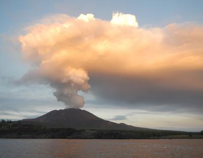
After the cruise some of the scientists set sail on a smaller boat to install seismometers on five islands surrounding the trench. The volcano that created one of these islands, Pagan, has erupted several times over the past 30 years. Fortunately it was only moderately active when the team was there, expelling steam that reflects the setting sun in this photo.
(Photo Credit: Heather Relyea)
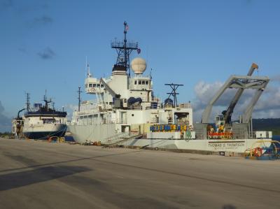
This is the Thomas G. Thompson and the Marcus G. Langseth at the Navy Pier in Guam. The Thompson laid seismic instruments, which are stacked and ready on its deck, and the Langseth then sailed transects over the instrumented area, firing its airgun array and recording the reflections from subsurface rock layers.
(Photo Credit: Doug Wiens)