NOAA's GOES-13 satellite spotted the remnant clouds and showers from former Tropical Storm Chantal lingering over the Bahamas on July 12. Chantal's chances for regeneration are diminishing because of upper-level winds.
A visible image from NOAA's GOES-13 satellite at 9:45 a.m. EDT on July 12, 2013 showed Chantal's remnant clouds and showers moving north in the Atlantic. The image of Chantal's remnants resembled the sideways view of a jellyfish. The GOES image was created by NASA's GOES Project at the NASA Goddard Space Flight Center, Greenbelt, Md.
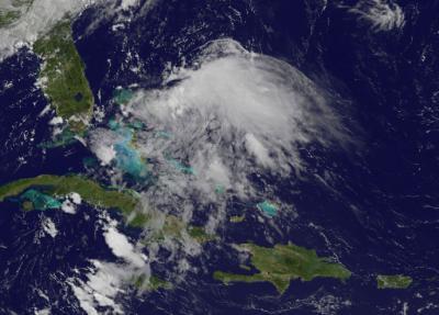
This visible image from NOAA's GOES-13 satellite shows the remnant clouds and showers from Chantal over the Bahamas and the adjacent Atlantic waters at 9:45 a.m. EDT on July 12, 2013.
(Photo Credit: NASA GOES Project)
The National Hurricane Center (NHC) noted that the remnants remain disorganized, and that development has become less likely. Upper-level winds helped cause the demise of the tropical cyclone and continue to affect the storm. On July 13 at 8 a.m. EDT, the NHC gave Chantal's remnants a 10 percent change of regenerating into a tropical cyclone during the next 48 hours. In fact, the NHC even canceled the Air Force reconnaissance mission scheduled for July 13.
Source: NASA/Goddard Space Flight Center