System 96E became a tropical depression and quickly grew into Tropical Storm Dalila on June 30. Dalila has been hugging the coast of southwestern Mexico practically since it formed, and continues to do so on satellite imagery taken on July 1.Because of its close proximity to the coast, there's a tropical storm warning in effect for the southwestern coast of Mexico from Punta San Telmo to La Fortuna, and a Tropical Storm Watch from north of La Fortuna. That means 1 to 3 inches of rainfall expected over coastal areas of the Mexican states of Micohcan, Colima and Jaliso, and tropical storm force winds, today, July 1.
On Sunday, June 30, Dalila's maximum sustained winds were near 40 mph (65 kph). By Monday, July 1 at 11 a.m. EDT, Dalila's maximum sustained winds increased to 60 mph (95 kph). The National Hurricane Center expects Dalila to reach hurricane force over the next couple of days.
The storm was moving to the northwest at 9 mph (15 kph) and is expected to turn west-northwest and head out to sea. It was centered near 17.8 north and 105.8 west, about 130 miles (205 km) south-southeast of Manzanillo, Mexico. Minimum central pressure dropped from 1003 millibars on June 30 to 998 millibars on July 1, indicating intensification was occurring over that time.

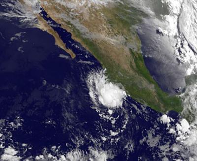
NOAA's GOES-15 satellite captured an image of Tropical Depression Dalila on July 1 at 12:00 UTC (8 a.m. EDT). Strong thunderstorms were firing up around the center of circulation, as Dalila's center was just off-shore near the southwestern Mexico coast.
(Photo Credit: : NASA GOES Project)
NOAA's GOES-15 satellite captured an infrared image of Tropical Depression Dalila on July 1 at 12:00 UTC (8 a.m. EDT) that showed how close to the southwestern coast of Mexico that Dalila is tracking. The image also showed strong thunderstorms were firing up around the center of circulation. The NOAA GOES image was created by the NASA GOES Project at NASA's Goddard Space Flight Center in Greenbelt, Maryland.
Two different computer models are presenting two different scenarios with Dalila, according to the National Hurricane Center (NHC). According to the latest NHC bulletin on the Dalila, the GFS model is forecasting a stronger storm that will move farther north, while the ECMWF model is forecasting a weaker storm that will move slowly southwest. The NHC forecast splits the difference on the intensity and calls for a westward motion in the next two days.
Source: NASA/Goddard Space Flight Center