A visible satellite image from NOAA's GOES-East satellite shows that Post-Tropical Storm Bertha was merging with a frontal system in the North Atlantic Ocean.
The visible image from 1200 UTC (8 a.m. EDT) on August 6 was created at the NASA GOES Project, located at NASA's Goddard Space Flight Center in Greenbelt, Maryland. The image was created from data from NOAA's GOES-East satellite and the circulation center of Bertha is barely discernable. Bertha's circulation was connected to a stationary front that stretched from northeastern Canada to the Bahamas creating what looks like a giant tail stretching from the low pressure area. Satellite imagery showed that there were no strong thunderstorms associated with Bertha's center.
At 11 a.m. EDT, the National Hurricane Center (NHC) noted that Bertha acquired extra-tropical characteristics. Bertha had maximum sustained winds near 50 mph (85 kph). It was centered near 40.2 north latitude and 62.7 west longitude, about 305 miles (495 km) south of Halifax, Nova Scotia, Canada. Bertha had maximum sustained winds near 50 mph (85 kph) and was speeding to the northeast at 31 mph (50 kph).
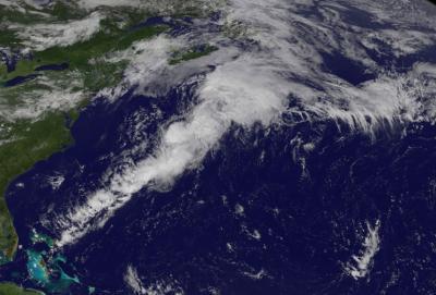
This GOES-East satellite image shows that Post-Tropical Storm Bertha has become associated with a frontal system and has acquired extra-tropical characteristics about 300 miles south of Halifax, Nova Scotia, Canada.
(Photo Credit: Image : NASA/NOAA GOES Project)
The NHC noted that the low is moving toward the northeast and is being steered by the mid-latitude westerlies [winds]. Most of the global models keep the post-tropical cyclone moving rapidly northeastward and then eastward over the North Atlantic.
Source: NASA/Goddard Space Flight Center