WASHINGTON--U.S. Naval Research Laboratory radio astronomer, Joseph Helmboldt, Ph.D., and researchers at Ohio State University Department of Civil, Environmental and Geodetic Engineering analyzed radio telescope interferometry and Global Positioning Satellite (GPS) data recorded of the ionosphere during one of the last underground nuclear explosions (UNEs) in the U.S., codenamed Hunters Trophy.
Situated in the Plains of San Agustin, 50 miles west of Socorro, New Mexico, twenty-seven 25-meter parabolic dish antennas collectively make up the National Radio Astronomy Observatory's Very Large Array (VLA) radio telescope.
The VLA is an interferometer; meaning it operates by multiplying the data from each pair of telescopes together to form interference patterns. The structure of those interference patterns, and how they change with time as the earth rotates, reflect the structure of radio sources on the sky.
Designed as a radio synthesis telescope, observing bands between 1 and 50 gigahertz (GHz), the VLA is chiefly used to observe cosmic sources. While such observations require detailed calibration schemes to remove the effects of the ionosphere, this calibration data is seldom used to actually study the ionosphere.
During the Hunters Trophy event at the Nevada Test Site, Sept. 18, 1992, the VLA was observing a series of relatively bright cosmic sources at 1.4 GHz and positioned in a compact D-configuration, allowing an increased sensitivity to smaller-scale fluctuations. The data for these observations were retrieved from the VLA archives and self-calibration was performed using each source to obtain differences in total electron content (ΔTEC) time series for each antenna.

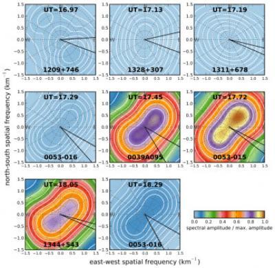
For each source observed near and after the Hunters Trophy event, maps of TEC gradient fluctuation power as a function of east-west and north-south spatial frequency. Here, the peak spectral power over all temporal frequencies is shown as an image in each panel with contours representing the mean power over all temporal frequencies. The range in azimuths expected for waves propagating from Hunters Trophy for altitudes between 100 and 900 km is shown in each panel with black lines.
(Photo Credit: U.S. Naval Research Laboratory)
"One can see that between roughly 20 and 25 minutes after the UNE, the signature of disturbances in the ionosphere moving toward the northeast and southwest are nearly perpendicular to the direction from Hunters Trophy," said Helmboldt. "Given their characteristics, it seems likely that these disturbances are associated with small-scale distortions propagating along the larger traveling ionospheric disturbance generated by the Hunters Trophy explosion."
GPS can also contribute to detection and discrimination of UNEs. GPS signals are sensitive to ionospheric disturbance, and this phenomenon can be used to further validate concurrent VLA measurements. By studying the ionosphere, namely Traveling Ionospheric Disturbances (TIDs) excited by acoustic-gravity waves from surface and underground explosions, the magnitude of the fluctuations greatly increased roughly 30 minutes after detonation -- consistent with GPS-derived propagation speed. The travel time and the travel distance of each event are highly correlated.
"Combining the results of both spectral techniques, we found a class of intermediate and small-scale waves," said Helmboldt. "Our exploration of VHF/UHF observations with the VLA has successfully demonstrated the power of this instrument to characterize a variety of transient ionospheric phenomena."
The resolution of the VLA is set by the size of the array -- up to 36 km (22 miles) across. At its highest frequency (43 GHz) a resolution of 0.04 arcseconds is achieved – sufficient to see a golf ball being held 150 km (100 miles) away.
Source: Naval Research Laboratory