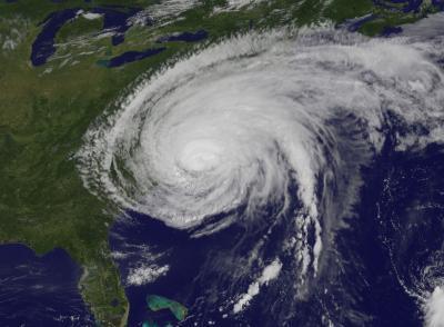
Boulder, Colorado, USA – A new study published in the December issue of GSA Today examines the geological legacy of Hurricane Irene, not only in terms of its impact on current coastal conditions but also in what it can tell geoscientists about the past. Hurricane Irene made landfall in Onslow Bay, North Carolina, USA, on 27 August 2011, at which time it had been downgraded to a Category 1 hurricane after hitting the Bahamas at Category 3 strength.
In their GSA Today article, geoscientists Scott P. Hippensteel, Matthew D. Eastin, and William J. Garcia of the University of North Carolina at Charlotte call for a better understanding of the long-term record of storm frequency and impact, not only because of the increase in the strength of storms hitting coastal areas but also because of the high population density in vulnerable areas along the U.S. East Coast and Gulf Coast.
Those who study the paleo-storm record explain that gaining understanding of past events provides the context for future coastal vulnerability. Hippensteel and colleagues apply evidence of what they call the "lack of a definitive signature" from Hurricane Irene to a 1500-year paleostorm record at Onslow Bay. They write that fewer hurricanes could be found in the fossil and sedimentary records (through bioturbation or foraminiferal dissolution) than had actually made landfall there.

Hurricane Irene made landfall in Onslow Bay, N.C., USA, on Aug. 27, 2011. Satellite image courtesy NASA.
(Photo Credit: NASA)
The authors infer that the lack of storm records in the marsh sediments from Onslow Bay means that only hurricane strikes of higher magnitude can provide proxies for understanding the paleostorm record, because only the most robust storm deposits are archived. The lack of definitive signs of Hurricane Irene in the area raises their concerns about the current understanding of hurricane deposition and preservation.
Source: Geological Society of America