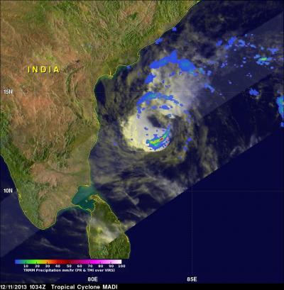
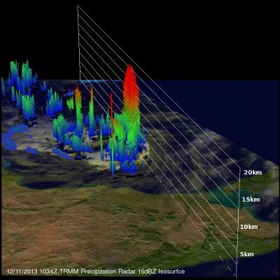
NASA's TRMM satellite spotted heavy rainfall and very high cloud tops in strong thunderstorms in the southern quadrant of Tropical Cyclone Madi on December 11 as it neared southeastern India's coast.
The Tropical Rainfall Measuring Mission or TRMM satellite flew over the Bay of Bengal and Tropical Cyclone Madi on December 11, 2013 at 1034 UTC/5:34 a.m. EST. TRMM's Microwave Imager (TMI) and Precipitation Radar (PR) instruments found that Madi contained powerful storms southeast of the center of circulation where rain was falling at a rate of over 81 mm/~3.2 inches per hour. An analysis of Madi's 3-D vertical structure using TRMM PR found that tops of these convective towers were reaching extremely high altitudes greater than 19km/~11.8 miles.
Since the time of the TRMM orbit over Tropical Cyclone Madi, the storm's maximum sustained winds dropped to 40 knots/46.0 mph/74.0 kph. Madi is expected to weaken to depression status later on December 11. It was centered near 13.1 north and 82.7 eat, about 165 nautical miles/189.9 miles/305.6 km east of Chennai, India. Madi is moving to the southwest at 7 knots/8.0 mph/12.9 kph.

TRMM satellite flew over tropical cyclone Madi in the Bay Of Bengal on Dec. 11, 2013 at 1034 UTC and saw storms southeast of MADI's center of circulation dropping rain at the rate of over 81 mm/~3.2 inches per hour (red).
(Photo Credit: : SSAI/NASA, Hal Pierce)
According to the Joint Typhoon Warning Center or JTWC, the overall structure of Madi's core appears to be losing its symmetry, becoming mildly elongated from east to west. The latest JWTC bulletin notes that given Madi's poor vertical alignment (the upper and lower level circulations are not stacked on top of each other), cooler sea surface temperatures, and the dry air that is moving into the western and southern edges of the storm, Madi is expected to keep weakening through the time of landfall.
India's Regional Specialised Meteorological Centre noted that rainfall is expected in isolated places over coastal Andhra Pradesh, coastal Tamil Nadu and Puducherry from December 11 at 10 a.m. EST/9 p.m. Asia/Kolkata local time to December 11 at 10 p.m. EST/9 a.m. Asia/Kolkata local time. Rainfall would occur at many places over Tamil Nadu & Puducherry with isolated heavy falls over coastal Tamil Nadu for the next two days. Landfall is expected on December 12 in southeastern Tamil Nadu.

TRMM satellite flew over tropical cyclone Madi in the Bay of Bengal on Dec. 11, 2013 at 1034 UTC and found some cloud tops of strong storms were reaching extremely high altitudes greater than 19km/~11.8 miles.
(Photo Credit: : SSAI/NASA, Hal Pierce)
Source: NASA/Goddard Space Flight Center