Tropical Cyclone Victoria is now a remnant low pressure area in the Southern Indian Ocean after running into strong wind shear that has been tearing the storm apart. When NASA's TRMM satellite passed over the storm on April 12 it saw limited areas with moderate rainfall pushed far from the center of circulation.
NASA and the Japan Aerospace Exploration Agency's Tropical Rainfall Measuring Mission (TRMM) satellite captured fading rainfall rates in dissipating Cyclone Victoria on April 12, 2013 at 0748 UTC (3:48 a.m. EDT). Wind shear has torn the storm apart and TRMM spotted limited areas where rain was falling at a rate of 30 mm (1.18 inches) per hour, pushed southeast of the center of circulation.
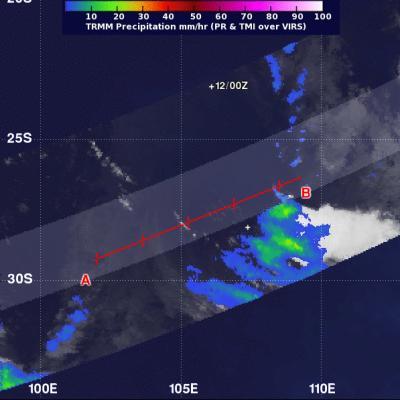
The TRMM satellite captured fading rainfall rates in dissipating Cyclone Victoria on April 12, 2013 at 0748 UTC (3:48 a.m. EDT). Wind shear has torn the storm apart and TRMM spotted limited areas where rain was falling at a rate of 30 mm per hour (green). The center of Victoria is marked "+12/00Z" in the image.
(Photo Credit: : NASA/SSAI, Hal Pierce)
On April 12 at 0300 UTC (April 11 at 11 p.m. EDT) the Joint Typhoon Warning Center issued their final warning on Victoria. At that time, Tropical Cyclone Victoria was located near 23.1 south latitude and 106.1 east longitude, about 445 nautical miles (512 miles/ 824 km) west of Learmonth, Australia. Victoria has moved south-southeast at 21 knots (24.8 mph/38.8 kph). Although Victoria's maximum sustained winds were near 35 knots (40 mph/ 64.8 kph), it has moved over cool waters and is being battered with strong wind shear. Victoria is expected to fully dissipate in the next day.
Source: NASA/Goddard Space Flight Center