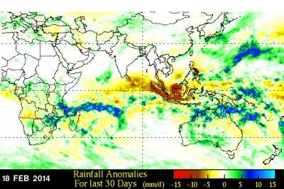
At NASA's Goddard Space Flight Center in Greenbelt, Md. a rainfall anomaly analysis was made by comparing rainfall data compiled during the twelve year period from 2001-2012 to "near real-time" Multi-satellite Precipitation Analysis data collected for the same period. That analysis showed that rainfall in the northern Mozambique Channel has been above normal for the past month.
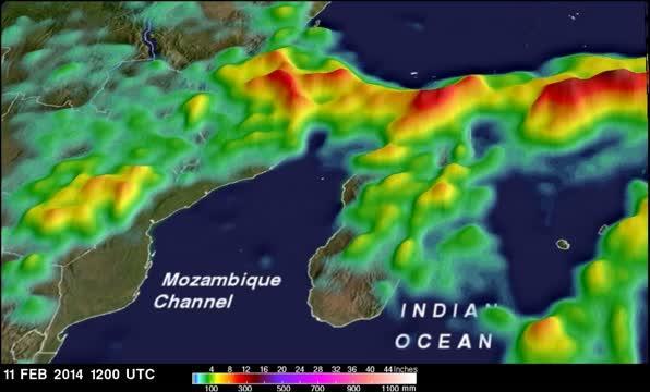
These rainfall estimates were used to create a simulated 3-D perspective view with higher precipitation amounts appearing to be taller than lower amounts. The highest totals, with amounts in the Mozambique Channel greater than 430 mm/~16.9 inches.
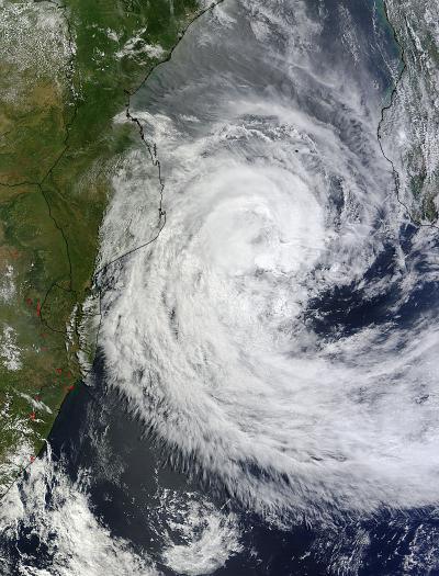
On Feb. 20 at 0800 UTC/3:00 a.m. EST, the Moderate Resolution Imaging Spectroradiometer or MODIS instrument that flies aboard NASA's Terra satellite showed that Cyclone Guito had moved farther south in the Mozambique Channel that the previous day. The MODIS image also showed that Guito's western fringes were brushing over Mozambique. In addition, multispectral satellite imagery showed that the strong convection associated with the low-level center of circulation had decreased.

This animation of rainfall gathered from Feb. 11-19, 2014, by NASA's TRMM satellite revealed that Tropical Cyclone Guito produced as much as 16.9 inches/430 mm of rainfall in the center of the Mozambique Channel and scattered light rain on Madagascar's western coast.
(Photo Credit: SSAI/NASA, Hal Pierce)
At 0900 UTC/4:00 a.m. EST, Guito was in the southern Mozambique Channel near 25.3 south latitude and 38.6 east longitude. That puts Guito's center over 575 nautical miles from the Capital city of Antananarivo, Madagascar. Guito's maximum sustained winds were near 65 knots/74.5 mph/120.4 kph (hurricane-force). It was moving to the south at 13 knots/14.9 mph/24.0 kph.
Guito is heading southeast and out of the Mozambique Channel and into the open waters of the Southern Indian Ocean. The Joint Typhoon Warning Center or JTWC noted that after 24 hours (by February 21 at 0900 UTC/4:00 a.m. EST), cooler sea surface temperatures and increasing vertical wind shear will take a toll on the tropical cyclone and start to weaken it.
JTWC forecasters expect by the second day that Guito will being transitioning into an extra-tropical storm, a process that will take another day over the open waters of the Southern Indian Ocean.

This visible image from NASA's Terra satellite on Feb. 20 at 0800 UTC shows that Cyclone Guito has moved south in the Mozambique Channel, and its western fringes were brushing over Mozambique.
(Photo Credit: NASA Goddard MODIS Rapid Response Team)

A TRMM rainfall anomaly analysis compiled from 2001-2012 data with "near real-time" Multi-satellite Precipitation Analysis data collected for the same period, shows that in part due to Guito, rainfall in the northern Mozambique Channel has been above normal for the past month.
(Photo Credit: SSAI/NASA, Hal Pierce)
Source: NASA/Goddard Space Flight Center