On June 7, there was good and bad news about System 90L. The good news was that it moved further inland and was dissipating so it no longer had a chance to develop into a tropical cyclone. The bad news was that it moved further inland and continued to produce gusty winds and heavy rains along with life-threatening flash flooding over eastern and southeastern Mexico.
At NASA's Goddard Space Flight Center in Greenbelt, Maryland, the NASA/NOAA GOES Project created an animation of satellite imagery from NOAA's GOES-East satellite imagery. The movie shows the movement of System 90L over land and dissipating between June 6 and June 7 at 2000 UTC (4 p.m. EDT).
The Mexican Weather Service reported the city of Veracruz recorded 7.1 inches (180 mm) of rain! Huixtepec in Oaxaca reported 2.9 inches (73.4 mm) of rain.
On June 7, the National Hurricane Center noted that the low was centered near 18.0 north and 96.5 west. By June 9, System 90L had dissipated.
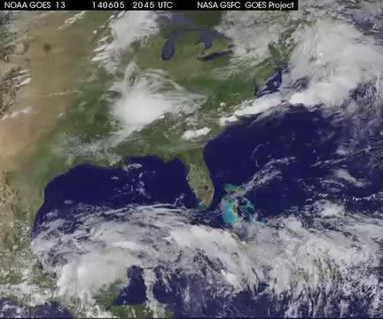
This movie of NOAA's GOES-East satellite imagery shows the movement of System 90L over land and dissipating between June 6 and June 7 at 2000 UTC (4 p.m. EDT).
(Photo Credit: Image : NASA/NOAA GOES Project)
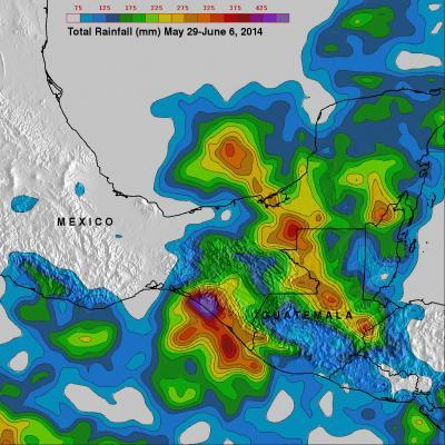
Rainfall totals were calculated using NASA's TRMM satellite data for the period May 29 to June 6, 2014 that included Tropical Storm Boris and System 90L. Over 535 mm (21.6 inches) where tropical storm Boris came ashore in southern Mexico.
(Photo Credit: Image : SSAI/NASA, Hal Pierce)
Source: NASA/Goddard Space Flight Center