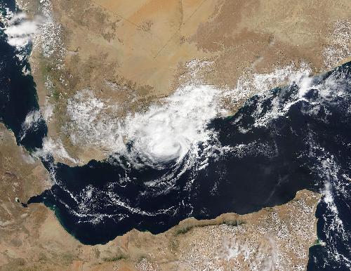
Tropical Cyclone Megh became the second tropical cyclone to make landfall in Yemen in one week. As Megh began land falling just north of Aden, Yemen, NASA's Terra satellite passed overhead and captured an image of the tropical storm over the southeastern coast.
When Terra flew over Megh from space, the Moderate Resolution Imaging Spectroradiometer or MODIS instrument aboard took a visible picture of the storm. The MODIS image showed a wide band of thunderstorms wrapped around the northwestern quadrant of the storm and a smaller band of thunderstorms wrapping around the eastern quadrant.
At 0300 UTC on November 10, 2015 (10 p.m. EST, Nov. 9) Tropical Cyclone Megh had maximum sustained winds near 35 knots (40 mph/62 kph). Megh had already made landfall and was centered just 15 nautical miles northeast of Aden, Yemen. It was centered near 13.0 degrees north latitude and 45.1 east longitude. It was moving to the west at 17 knots (19.5 mph/31.4 kph).
 At 07:25 UTC (2:45 a.m. EDT) on Nov. 10, NASA's Terra satellite saw Tropical Cyclone Megh making landfall over Yemen. Credit: Credits: NASA Goddard MODIS Rapid Response Team
Forecasters at the Joint Typhoon Warning Center (JTWC) expect Megh to dissipate quickly from the dry air from the desert environment of Yemen.
source: NASA/Goddard Space Flight Center