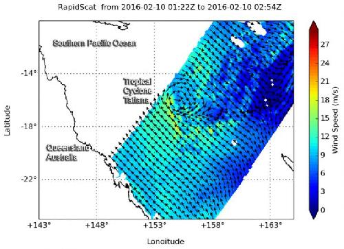
As Tropical Cyclone Tatiana was developing in the Coral Sea, east of Queensland, Australia, NASA's RapidScat measured the surface winds in the intensifying tropical cyclone.
RapidScat saw strongest sustained winds near 18 meters per second (40 mph/64 kph) in the western and southern sides of developing Tropical Cyclone Tatiana on Feb. 10. RapidScat flies aboard the International Space Station and can measure winds on the ocean's surface. Forecasters are able to use RapidScat data to pinpoint the strongest winds within a storm, as they are not always equally distributed.
The Australian Bureau of Meteorology noted that Tropical cyclone Tatiana is situated well offshore and poses no immediate threat to the Queensland coast.
 RapidScat saw strongest sustained winds (yellow) in Tropical Cyclone Tatiana on Feb. 10 were on the western and southern sides of the storm, at 18 meters per second (40 mph/64 kph). Credit: Credits: NASA JPL, Doug Tyler
On Feb. 11 at 03:50 UTC (Feb. 10 at 10:50 p.m. EST) the Visible Infrared Imaging Radiometer Suite (VIIRS) instrument aboard NASA-NOAA's Suomi NPP satellite captured a visible image of Tropical Cyclones Tatiana east of Queensland, Australia and newborn Tropical Cyclone Winston east of Vanuatu in the South Pacific Ocean.At 0900 UTC (4 a.m. EST), Tropical Cyclone Tatiana had maximum sustained winds near 45 knots (49.7 mph/80 kph. It was centered near 16.9 degrees south latitude and 157.9 degrees east longitude, about 559 nautical miles west-northwest of Noumea, New Caledonia. Tatiana was moving to the east at 5 knots (5.7 mph/9.2 kph).
The Joint Typhoon Warning Center forecast calls for Taitana to move southeast and intensify to 55 knots (63.2 mph/101.9 kph). It is forecast to pass far to the west of New Caledonia, weaken and dissipate by February 15.
source: NASA/Goddard Space Flight Center