NASA's Hurricane and Severe Storms Sentinel airborne mission known as HS3 wrapped up for the 2013 Atlantic Ocean hurricane season at the end of September, and had several highlights. HS3 will return to NASA's Wallops Flight Facility in Wallops Island, Va., for the 2014 Atlantic hurricane season.
During the 2013 mission, two unmanned Global Hawks flew from Wallops for the first time. The mission highlights included studying the Saharan Air Layer, following the genesis of a tropical storm, finding a unique hybrid core or center circulation in a redeveloped storm, obtaining measurements on the strongest side of one of this season's few hurricanes, an investigation of a storm that was almost certain to develop but didn't, and a landmark 100th flight for the Hawks.
"We were able to obtain some excellent data on the Saharan air layer; multiple flights covering the life cycle of Tropical Storm Gabrielle; and an excellent flight for a system in the southern Gulf of Mexico that, despite having a ~70 percent chance of forming, failed to form," said Scott Braun, HS3 principal investigator at NASA's Goddard Space Flight Center in Greenbelt, Md. "However, from a science perspective, it was disappointing because of the low amount of tropical cyclone activity."
The Global Hawks were based at Wallops from mid-August to the end of September.
Examining the Saharan Air Layer
One of NASA's Global Hawks flew over the remnants of Tropical Storm Erin and captured data on the Saharan Air Layer or SAL in the Eastern Atlantic Ocean on Aug. 20 and 21. Known as HS3's environmental Global Hawk, the aircraft carries a payload of instruments that include the CPL or Cloud Physics Lidar, S-HIS or Scanning High-Resolution Interferometer Sounder Instrument, and NOAA's dropsonde system.
A sonde is a device that measures winds, temperature and humidity as it falls through the atmosphere. Sondes were dropped out of the tail of the Global Hawk during the mission.
The CPL instrument analyzed the SAL and showed an elevated dust layer between about 1.5 and 2.8 miles/2.5 and 4.5 km overrunning the remnants of Erin. The low-level clouds associated with what was left of Erin were located below 1.2 miles/2 km. Data showed that the SAL moved right over Erin's remnants. HS3 conducted a second flight into a large SAL air mass on Aug. 24-25 that provided a unique combination of data from the dropsonde system and CPL. The data captured the tremendous variability in dust layer structure that occurs within the broader air mass.

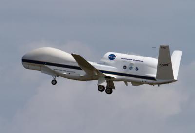
NASA's Global Hawk unmanned aircraft project celebrated a flight milestone on Sept. 17, 2013. The two Global Hawks reached a combined 100 NASA flights during the deployment at the Wallops Flight Facility. In this photo, NASA's Global Hawk 872 takes off from Runway 04 on Sept. 4.
(Photo Credit: NASA's Wallops Flight Facility)
Identifying a Unique Hybrid Core
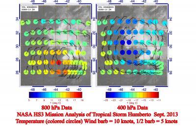
HS3's environmental Global Hawk gathered data from Tropical Storm Humberto on Sept. 16 and 17 after it was reborn from the original storm's remnants. Braun combined dropsonde data with a satellite image from NOAA's GOES-East satellite. The dropsonde data, centered on 0000 UTC/8 p.m. EDT Sept. 17, revealed that Humberto was a hybrid storm. Humberto's hybrid structure was the result of a union of the low-level warm-core tropical storm with an upper-level cold low, so it had a structure that was more of a hybrid, or combination, of a tropical and extra-tropical system.
Measuring a Hurricane's Heavy Rain and Strong Winds
HS3's over-storm Global Hawk, which focuses on measurements of storm internal structure, carried the Hurricane Imaging Radiometer or HIRAD, the High-altitude Imaging Wind and Rain Airborne Profiler or HIWRAP, and the High-Altitude Monolithic Microwave Integrated Circuits Sounding Radiometer or HAMSR, on a flight over Hurricane Ingrid on Sept. 15 as the storm moved through the extreme southwestern Gulf of Mexico and traveled west-northwestward along Mexico's east coast. HIRAD identified an area of heavy rain and likely strong winds on Hurricane Ingrid's eastern side by measuring energy coming from the rough ocean surface caused by the rain and strong winds.
"HIRAD data definitely saw most of the strong wind and heavy rain on the northern and eastern sides of Hurricane Ingrid in the area generally near 23 degrees north latitude and 95 degrees west longitude," said Daniel J. Cecil, the principal investigator for the HIRAD instrument at NASA's Marshall Space Flight Center in Huntsville, Ala.
The Storm That Didn't Develop
On Sept. 19-20, HS3's environmental Global Hawk was sent to investigate and gather data from a low pressure system designated Invest 95L, located in the Bay of Campeche. The National Hurricane Center gave Invest 95L a 70 percent chance for development into a tropical depression, but that never occurred. While HS3 data indicated the occurrence of a weak closed circulation at the surface and somewhat stronger circulation just above the surface, rain shower and thunderstorm activity was largely suppressed, preventing development. "Dropsonde data suggested a layer of sinking air motions in the upper half of the troposphere, the layer of the atmosphere containing most weather. Such sinking motions typically suppress cloud development and dry out the air and likely contributed to the lack of development," said Braun.
National Hurricane Center Uses HS3 Data from Tropical Storm Gabrielle
NASA's Global Hawk dropsonde data assisted forecasters at the National Hurricane Center when they analyzed the environment of Tropical Depression 7 that became Tropical Storm Gabrielle at 11 p.m. EDT on Sept. 4.
The NHC discussion at 11 p.m. EDT on Sept. 4 noted: Dropsonde data from the NASA Global Hawk aircraft suggest that the circulation of Gabrielle is tilted to the northeast with height...with a mid-level circulation seen in data from the San Juan WSR-88d Radar. This tilted structure is consistent with southerly to southwesterly vertical shear of 5 to 10 knots shown over the cyclone by the University of Wisconsin Cooperative Institute for Meteorological Satellite Studies and other analyses. In addition the dropsonde data showed dry air in the mid-levels of the atmosphere around Gabrielle that led NHC forecasters to note that not much strengthening was expected in the short term.
Milestone Flight for Global Hawks
NASA's Global Hawk unmanned aircraft project celebrated a flight milestone on Sept. 17, 2013. The two Global Hawks reached a combined 100 NASA flights during the deployment at the Wallops Flight Facility. NASA's environmental Global Hawk returned to Wallops on Sept. 17 after making its 75th flight and the over-storm Global Hawk departed from Wallops marking its 25th flight.
Although tropical activity was unusually low and there were no major hurricanes, scientists were able to gather a large amount of data on several storms and explore the Saharan Air Layer using the two Global Hawks and their unique suites of instruments.
The HS3 mission came to an end when NASA 872 departed at 9:49 a.m. EDT on Sept. 26, 2013, on a 10-hour flight back to NASA Dryden Flight Research Center on Edwards Air Force Base, Calif.

Dropsonde data from lower and higher levels within Tropical Storm Humberto between Sept. 16 and 17 are overlaid on an infrared GOES satellite image shows temperature (colored circles) and wind barbs at 800 (left) and 400 (right) hPa. Full wind barbs are 10 knots.
(Photo Credit: NASA)
Source: NASA/Goddard Space Flight Center