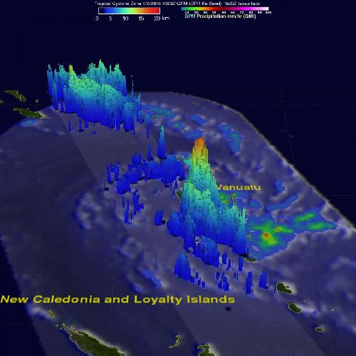
Tropical Cyclone Zena, formerly known as Tropical Cyclone 18P formed in the South Pacific Ocean near Vanuatu early on April 5, 2016. The Global Precipitation Measurement or GPM core observatory satellite flew directly above the newly formed tropical cyclone and measured rainfall and cloud heights in the storm.
Intensifying tropical cyclone Zena was buffeting Vanuatu with sustained winds estimated to be over 35 knots (40 mph) when GPM flew overhead on April 5, 2016 at 1023 UTC. A rainfall analysis derived from GPM's Microwave Imager (GMI) and Dual-Frequency Precipitation Radar (DPR) instruments showed that very powerful storms moving through the islands were dropping rain at a rate of almost 154 mm (6 inches) per hour in intense downpours.
On April 6, warnings were up in Fiji as Zena approached. A hurricane warning was posted for Vatulele, Beqa, Kadavu, and a storm warning was in effect for southern Viti Levu from Momi to Nausori and southern Lau group. In addition, a gale warning was in effect for Yasawa, Mamanuca group, rest of Viti Levu, Lomaiviti and northern Lau group.
 On April 5, GPM saw Zena was dropping rain at a rate of almost 154 mm (6 inches) per hour in intense downpours. Credit: Credits: NASA/JAXA/SSAI, Hal Pierce
On April 6 at 0900 UTC (5 a.m. EDT), Tropical Cyclone Zena had maximum sustained winds near 80 knots (92 mph/148.2 kph). It was located near 18.5 south latitude and 175.1 east longitude, about 190 nautical miles west of Suva, Fiji. Zena was moving quickly to the east-southeast at 23 knots (26.4 mph/42.6 kph).
The Joint Typhoon Warning Center (JTWC) noted that Zena was starting to weaken as it moves east-southeast. JTWC forecasters expect that Zena will transition to a sub-tropical cyclone within two days.
source: NASA/Goddard Space Flight Center