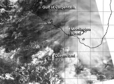
A tropical low pressure area known as "System 94P" has tracked across western Queensland and moved into the Gulf of Carpentaria between Karumba and Gilbert River Mouth on February 3 as NASA's Aqua satellite passed overhead.
System 94P continues to struggle to organize into a tropical depression, and the Australian Bureau of Meteorology or ABM has dubbed the storm "Fletcher." ABM expects the low pressure area to bring heavy rain to the Gulf Country district, mostly to coastal parts areas over the next couple of days. ABM noted that Kowanyama recorded 5.7 inches /147 mm of rain on Feb. 3 and it was still raining.
ABM posted Cyclone Warning for coastal and island communities from Mornington Island to Gilbert River Mouth, and a Cyclone Watch was in effect for coastal areas from the Northern Territory and Queensland border to Mornington Island.

NASA's Aqua satellite captured a visible image of System 94P on Feb. 3 at 0505 UTC as it moved into the Gulf of Carpentaria and its northwestern quadrant covered Mornington Island and Bentick Island.
(Photo Credit: : Naval Research Laboratory/NASA)
The Moderate Resolution Imaging Spectroradiometer or MODIS instrument aboard NASA's Aqua satellite captured a visible image of System 94P as it moved into the Gulf of Carpentaria and its northwestern quadrant covered Mornington Island and Bentick Island. Half of the tropical low was over the Gulf and the other half was over land.
At 0400 UTC on February 3, maximum sustained winds were estimated to be near 30 knots/34.5 mph/55.5 kph. The Joint Typhoon Warning Center or JTWC has issued Tropical Cyclone Formation Alert WTPS21, as forecasters expect the low to strengthen into tropical depression status. System 94P was centered near 17.3 south and 140.0 east, about 50 nautical miles/57.5 miles/92.6 kph southeast of Mornington Island.
The JTWC noted that animated multispectral satellite imagery showed that the well-defined low-level center was consolidating over the open waters, and that strong bands of thunderstorms were wrapping into the center. Radar imagery from Mornington Island confirmed the strong thunderstorms and the well-defined center of circulation.
Source: NASA/Goddard Space Flight Center