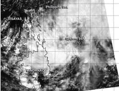
The tropical low pressure area centered just east of the southern Philippines appeared more organized on visible imagery from NASA's Aqua satellite on March 21. System 94W appears to be developing and the Philippine authorities have already issued warnings on the system locally designated as "Caloy."
The MODIS instrument (Moderate Resolution Imaging Spectroradiometer) that flies aboard NASA's Aqua satellite captured a visible image of System 94W coming together east of the southern Philippines on March 21 at 5:25 UTC/1:25 a.m. EDT. The image revealed a circulation with the center over the open waters of the Northwestern Pacific Ocean. The image showed bands of thunderstorms from System 94W's western quadrant was draped over the eastern Mindanao region (southern area) of the Philippines and bands of thunderstorms from the storm were over the waters of the Northwestern Pacific Ocean.
Warnings were posted by the Philippine Atmospheric, Geophysical and Astronomical Services Administration (PAGASA) on March 21 at 5 p.m. Signal No. 1 is in effect for parts of the Visayas and Mindanao regions of the Philippines today, March 21.
Signal No. 1 means that sustained winds of 18.6-37.2 mph/30-60 kph may be expected in at least 36 hours. In Visayas, those areas under Signal No. 1 include: Southern Leyte, Bohol, Siquijor, Southern Cebu, the southern part of Negros Occidental and the southern part of Negros Oriental.

The MODIS instrument aboard NASA's Aqua satellite captured this visible image of low pressure "System 94W" coming together east of the southern Philippines on March 21.
(Photo Credit: NRL/NASA)
In Mindanao, Signal No. 1 is in effect for Southern Leyte, Bohol, Siquijor, Southern Cebu, the southern part of Negros Occidental, and the southern part of Negros Oriental. For additional updates from PAGASA, please visit: http://www.pagasa.dost.gov.ph//
On March 21 at 5 p.m. local time, PAGASA noted that the center of System 94W was located near 8.9 north latitude and 127.8 east longitude, about 310 km/192.6 miles northeast of Davao City or at 170 km/105.6 miles East Northeast of Hinatuan, Surigao del Sur.
The Joint Typhoon Warning Center gives System 94W a high chance for developing into a tropical depression in the next day. Meanwhile, PAGASA expects the low to move to the west-northwest over the next couple of days and cross the southern Philippines.
Source: NASA/Goddard Space Flight Center