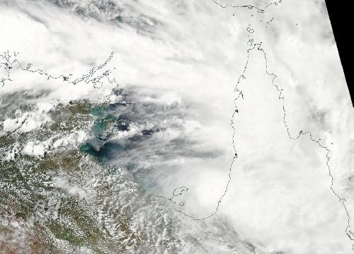
The sixteenth tropical cyclone of the Southern Pacific Ocean season was forming in the southern Gulf of Carpentaria on March 16 as NASA's Aqua satellite captured a visible picture of the storm. The storm is already headed for landfall in Queensland, Australia, and is not expected to strengthen.
Tropical Cyclone 16P (16P) came together on March 17 at 0300 UTC (March 16 at 11 p.m. EDT). It was centered just 60 nautical miles (60.9 miles/111.1 km) east-northeast of Mornington Island, Australia, near 16.3 degrees south latitude and 140.2 degrees east longitude. 16P had maximum sustained winds near 35 knots (40 mph/62 kph) and was moving to the east-southeast at 9 knots (10.3 mph/16.6 kph).
16P is expected to make landfall later today near the mouth of the Gilbert River in Queensland, located between Kowanyama to the north and Karumba to the south.
 On Mar. 16, 2016 NASA's Aqua satellite captured this visible image of Tropical Cyclone 16P in Australia's southern Gulf of Carpentaria. Queensland is the east (right). Credit: Credits: NASA Goddard MODIS Rapid Response Team
The Australian Bureau of Meteorology noted on March 16, "The Cyclone Warning between Karumba and Cape Keerweer has been cancelled. The low has moved rapidly eastwards during the day and is now close to the coast. It is no longer expected to intensify into a tropical cyclone. Heavy rainfall which may lead to flash flooding may still develop between Kowanyama and Karumba later today."
source: NASA/Goddard Space Flight Center