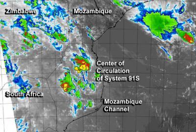
NASA's Aqua satellite provided infrared data on System 91S in the Mozambique Channel that showed a system battered by wind shear, stretched out, with broken convection.
A false-colored infrared image was created at the Naval Research Laboratory in Washington, D.C. using infrared data from the MODIS instrument aboard NASA's Aqua satellite on January 31 at 11:05 UTC/6:05 a.m. EST. The MODIS image showed the strongest thunderstorms associated with System 91S to the west-northwest of the center (over Mozambique), as a result of strong wind shear. Satellite data also revealed that the center of circulation is now elongated and that the strongest convection (rising air that forms the thunderstorms that make up a tropical cyclone) is occurring over the northwestern quadrant of the storm's center.
On January 31, System 91S had maximum sustained surface winds between 20 to 25 knots/37.0 to 46.3 kph/23.0 to 28.7 mph. Minimum sea level pressure was estimated to be near 1004 millibars.

This false-colored infrared image from the MODIS instrument aboard NASA's Aqua satellite shows the strongest thunderstorms associated with System 91S to the west-northwest of the center over Mozambique.
(Photo Credit: NRL/NASA)
Vertical wind shear continues to batter the tropical low, and the Joint Typhoon Warning Center expects the system to weaken as it moves south through the Mozambique Channel (between Mozambique on the African mainland and the island nation of Madagascar).
The Joint Typhoon Warning Center gives System 91S a low chance of development as it continues to deal with moderate to strong wind shear over the next couple of days.
Source: NASA/Goddard Space Flight Center