Two of NASA's "eyes" have been watching Tropical Cyclone Daya and providing data to forecasters. As Tropical Cyclone Daya continued to move away from La Reunion Island in the Southern Indian Ocean, NASA's RapidScat instrument and NASA's Aqua satellite gathered visible imagery and infrared temperature data on the developing storm that showed its strength and development.
On Feb. 10 at 2300 UTC (6 p.m. EST) the RapidScat instrument that flies aboard the International Space Station measured the surface winds within Tropical Cyclone Daya. RapidScat saw strongest winds were in the eastern and southeastern quadrants of the storm, as high as 27 meters per second (60.4 mph/97.2 kph). Sustained winds around the rest of the circulation were less strong.
RapidScat is an important tool for meteorologists, because maximum sustained winds are not always equally distributed in a storm. RapidScat shows forecasters the location of the strongest winds in different quadrants of a storm, indicating locations facing greatest impacts.
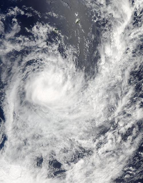
 NASA's Aqua satellite captured a visible image of Tropical Cyclone Daya in the Indian Ocean on Feb. 11 at 0950 UTC (4:50 a.m. EST). Credit: Credits: NASA MODIS Rapid Response Team
On Feb. 10 the Atmospheric Infrared Sounder (AIRS) instrument aboard Aqua saw cloud top temperatures exceeding -63 degrees Fahrenheit (-53 degrees Celsius) south of the center of circulation. On Feb. 11, AIRS data showed cloud top temperatures that cold had expanded in area to the southern and western quadrants of the storm, where the most powerful thunderstorms were located.
Another instrument aboard Aqua satellite captured a visible image of Tropical Cyclone Daya on Feb. 11 at 0950 UTC (4:50 a.m. EST). The Moderate Resolution Imaging Spectroradiometer or MODIS instrument's visible image confirmed with the AIRS infrared data showed: the most powerful thunderstorms were south and southwest of the center.At 1500 UTC (10 a.m. EST), Tropical cyclone Daya, formerly Tropical Cyclone 10S, was situated between La Reunion Island to the northeast and Madagascar to the west. It was near 26.5 degrees south latitude and 54.9 degrees east longitude, about 361 nautical miles south of La Reunion Island. Daya's maximum sustained winds were near 45 knots (49.7 mph/80 kph) and it was moving away from land areas to the southeast at 12 knots (13.8 mph/22.2 kph).
Daya is expected to start to weaken after today as it continues to encounter increasing vertical wind shear, according to the Joint Typhoon Warning Center. It is expected to dissipate in a day or two.
source: NASA/Goddard Space Flight Center