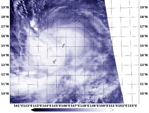
Tropical Storm Champi was over Guam and the Marianas Islands when NASA-NOAA's Suomi NPP satellite captured a visible image of the storm. On October 16, Champi was moving farther away from Saipan and Tinian in a westerly direction.
The Visible Infrared Imaging Radiometer Suite (VIIRS) instrument aboard NASA-NOAA's Suomi NPP satellite saw Tropical Storm Champi on October 16 at 0409 (12:09 a.m. EDT). The visible-light VIIRS image showed strongest thunderstorms associated with the tropical cyclone were in the storm's western quadrant and over Guam. Guam is a U.S. island territory in Micronesia, in the Western Pacific.
On October 16, 2015 at 5 a.m. EDT/0900 UTC, the center of Tropical Storm Champi was located near latitude 15.8 north and longitude 144.7 west. The storm is about 127 nautical miles (146 miles/235 km) north of Saipan and moving west at 17 knots (19.5 mph/31.4 kph). Maximum sustained winds were near 60 knots (69 mph/111 kph).
 Credit:
The National Weather Service in Guam continued its tropical storm warning for Rota, Tinian and Saipan. For updated forecasts for Guam, visit the National Weather Service website: http://www.prh.noaa.gov/pr/guam/.
The Joint Typhoon Warning Center forecast calls for Champi to move in a west-northwesterly direction and curve to the north-northeast and then northeast by October 20, taking it just east of the island of Iwo To, Japan.
source: NASA/Goddard Space Flight Center