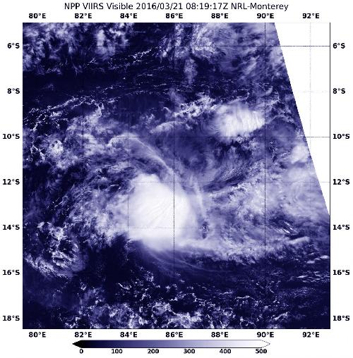
NASA-NOAA's Suomi NPP satellite passed over Tropical Cyclone Emeraude on March 21 as it continued weakening in the Southern Indian Ocean.
The Visible Infrared Imaging Radiometer Suite (VIIRS) instrument aboard Suomi NPP satellite captured a visible image of Tropical Cyclone Emeraude at 0819 UTC (4:19 a.m. EDT) that showed the storm had become slightly elongated.
The storm was located near 11.7 degrees south latitude and 86.1 degrees east longitude, about 851 nautical miles east-southeast of Diego Garcia.. Maximum sustained winds near 55 knots (63.2 mph/101.9 kph). It was moving to the west-southwest at 8 knots (9.2 mph/14.8 kph).
 NASA-NOAA's Suomi NPP satellite captured a visible image of Tropical Cyclone Emeraude on Mar. 21 at 0819 UTC in the Southern Indian Ocean. Credit: Credits: NOAA/NASA/NRL
The Joint Typhoon Warning Center noted that Emeraude has a partially exposed low level circulation center and the associated convection, clouds and showers were pushed to the west of the center. That's because in the upper levels of the atmosphere, there is a marginal with 10 to 20 knot northeasterly vertical wind shear.
Emeraude will continue to weaken over the next couple of days as it moves on a westerly track through the open waters of the Southern Indian Ocean.
source: NASA/Goddard Space Flight Center