"The use of the day-night band by the National Weather Service isgrowing," said Mitch Goldberg, program scientist for NOAA's JointPolar Satellite System. For example, the NOAA Weather Service'sforecast office in Monterey, Calif., is now using VIIRS day-nightband images to improve monitoring and forecasting of fog and lowclouds for high air traffic coastal airports like San Francisco.According to Goldberg, VIIRS images were used on Nov. 26, the Mondayafter Thanksgiving, to map the dense fog in the San Francisco Bayarea that resulted in flight delays and cancellations.
Unlike a camera that captures a picture in one exposure, the day-nightband produces an image by repeatedly scanning a scene and resolvingit as millions of individual pixels. Then, the day-night band reviewsthe amount of light in each pixel. If it is very bright, a low-gainmode prevents the pixel from oversaturating. If the pixel is verydark, the signal is amplified.
"It's like having three simultaneous low-light cameras operating atonce and we pick the best of various cameras, depending on wherewe're looking in the scene," Miller said. The instrument can captureimages on nights with or without moonlight, producing crisp views ofEarth's atmosphere, land and ocean surfaces.
"The night is nowhere as dark as we might think," Miller said. Andwith the VIIRS day-night band helping scientists to tease outinformation from human and natural sources of nighttime light, "wedon't have to be in the dark anymore, either."
"The remarkable day-night band images from Suomi NPP have impressedthe scientific community and exceeded our pre-launch expectations,"said James Gleason, Suomi NPP project scientist at NASA's GoddardSpace Flight Center in Greenbelt, Md.
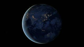
This new global view and animation of Earths city lights is a composite assembled from data acquired by the Suomi NPP satellite. The data was acquired over nine days in April 2012 and 13 days in October 2012. It took 312 orbits to get a clear shot of every parcel of Earth's land surface and islands. This new data was then mapped over existing Blue Marble imagery of Earth to provide a realistic view of the planet.HIGHER RESOLUTION ANIMATION: http://earthobservatory.nasa.gov/NaturalHazards/view.php?id=79803
(Photo Credit: NASA Earth Observatory/NOAA NGDC)

This image of the continental United States at night is a composite assembled from data acquired by the Suomi NPP satellite in April and October 2012. The image was made possible by the satellite's "day-night band" of the Visible Infrared Imaging Radiometer Suite (VIIRS), which detects light in a range of wavelengths from green to near-infrared and uses filtering techniques to observe dim signals such as city lights, gas flares, auroras, wildfires and reflected moonlight.
(Photo Credit: NASA Earth Observatory/NOAA NGDC)
Source: NASA/Goddard Space Flight Center