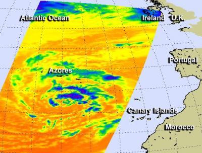
System 90L has developed in the eastern Atlantic Ocean today and NASA's Aqua satellite took an infrared look at the low pressure area to see if it had development potential. System 90L was located near 31.8 north and 28.1 west, about 450 miles south of the Azores Islands.
NASA's Aqua satellite passed over the low pressure area on Dec. 5 and the Atmospheric Infrared Sounder or AIRS instrument captured infrared data on the clouds, revealing the strongest thunderstorms northeast of the center. The low is non-tropical and is generating tropical-storm-force winds near 60 mph.

NASA's Aqua satellite passed over the low pressure area on Dec. 5 and the Atmospheric Infrared Sounder or AIRS instrument captured infrared data on the clouds, revealing the strongest thunderstorms northeast of the center.
(Photo Credit: Image : NASA JPL, Ed Olsen)
The low is expected to be affected by strong upper-level winds shear and move over colder waters, both of which will inhibit and likely prevent organization. The National Hurricane Center gives it a low chance of becoming a subtropical or tropical cyclone in the next couple of days.
Source: NASA/Goddard Space Flight Center