Tropical Cyclone Lehar is weakening as it heads for a landfall in eastern India. NASA's Aqua satellite captured an image of the storm nearing the coast today, November 27.
Warnings were in effect in India for northern Andhra Pradesh and southern Odisha as Lehar approaches. Lehar will bring winds, heavy rainfall and storm surge to those Indian states today, and tomorrow. A storm surge of up to 3 meters is possible.
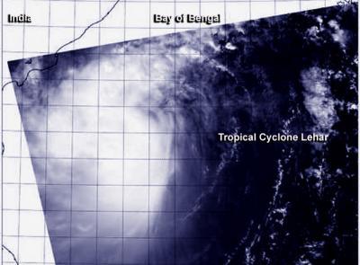
The MODIS instrument aboard NASA's Aqua satellite captured a visible image of Tropical Cyclone Lehar nearing the coast of central India on Nov. 27 at 0715 UTC/2:15 a.m. EST. The MODIS image showed bands of thunderstorms extending from the northern and southern quadrants of the storm, wrapping into the center. There was no visible eye, despite Lehar being at minimal hurricane-strength.

The MODIS instrument aboard NASA's Aqua satellite captured this visible image of Tropical Cyclone Lehar nearing the coast of central India on Nov. 27 at 0715 UTC.
(Photo Credit: Image : NRL-Monterey/NASA)
At 1500 UTC/10 a.m. EST on November 27, Lehar's maximum sustained winds were near 55 knots/63.2 mph/101.9 kph. Tropical-storm-force winds extended out 105 nautical miles/120.8 miles/194.5 km from the center of circulation, and the center was about 195 nautical miles southeast of Visakhapatnam, India. That puts the center near 15.1 north and 84.2 east. Lehar is generating high and rough seas with wave heights to 24 feet/7.3 meters as it moves to the west-northwest at 12 knots/13.8 mph/22.2 kph.
The Joint Typhoon Warning Center expects Lehar to strengthen a little more before making landfall in eastern India on November 27 at 0700 UTC/2 a.m. EST. By November 28 Lehar is expected to dissipate.
Source: NASA/Goddard Space Flight Center