Tropical Cyclone Atu had a brief but memorable life last week, and NASA's Atmospheric Infrared Sounder (AIRS) instrument that flies aboard NASA's Aqua satellite captured a day-by-day look at its growth and death.
AIRS provides infrared images of atmospheric phenomena, oceans and land areas around the world. Basically, infrared data takes the temperature of these things. When NASA's Aqua satellite flew over Tropical Cyclone Atu from February 21 through the 25 it saw thunderstorm cloud tops grow colder as the clouds grew higher and thunderstorms became more powerful. When cloud top temperatures reached the threshold of -63 Fahrenheit/-52 Celsius they indicated strong thunderstorms dropping heavy rainfall. By the 25th, Atu had run into strong wind shear and had dissipated north of New Zealand.
On Feb. 21 at 02:17 UTC, NASA's Aqua satellite flew over Tropical Cyclone Atu when it was over New Caledonia and Vanuatu bringing rainfall and gusty winds. On Feb. 22 at 13:53 UTC, AIRS showed an intensifying tropical Storm Atu with a developing eye.
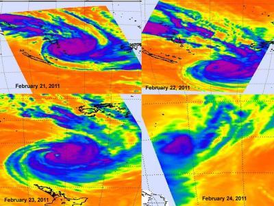
This time series of AIRS imagery shows the progression and death of Tropical Cyclone Atu. On Feb. 21 at 02:17 UTC Tropical Cyclone Atu when it was over New Caledonia and Vanuatu bringing rainfall and gusty winds. On Feb. 22 at 13:53 UTC, AIRS showed an intensifying Cyclone Atu with a developing eye. On Feb. 23 at 02:05 UTC, AIRS data showed a powerful cyclone with strong thunderstorms (purple), heavy rain and a visible eye on infrared imagery. The AIRS infrared data on Feb. 24 at 01:11 UTC showed Atu as a small rounded area of weak convection (blue).
(Photo Credit: NASA/JPL, Ed Olsen)
Tropical Cyclone Atu was at its strongest on February 22 near 0900 UTC (4 a.m. EST), when it was about 315 miles (506 km) east of Noumea, New Caledonia, near 22.7 South and 172.1 East. It had maximum sustained winds of 95 knots (109 mph/175 kmh) at that time. It was moving at 15 knots (17 mph/28 kmh) in a southerly direction, and was starting to weaken. By mid-day on Feb. 22, the warnings for Vanuatu had been discontinued, and there were some warnings still in effect for New Caledonia for winds in excess of 20 knots (23 mph/37 kmh) and high ocean swells.
On Feb. 23 at 02:05 UTC, AIRS data showed a powerful cyclone with strong thunderstorms, heavy rain and a visible eye on infrared imagery. On February 23, at 0900 UTC (4 a.m. EST), Tropical Cyclone Atu had maximum sustained winds of 70 knots (80 mph/129 kmh) with higher gusts. Tropical storm-force winds extended out to 140 miles (225 km) from the center of Atu. Cyclone-force winds extended to a much smaller area, only about 60 miles (95 km) in diameter. It was located in the southwestern Pacific Ocean near 28.5S and 176.5E, about 500 miles (804 km) south-southwest of Nadi, Fiji. At that time, it was moving southeast near 22 knots (25 mph/40 kmh). Atu was generating high waves in the open ocean, with wave heights reaching 30 feet (9 meters). Atu was weakening and becoming an extra-tropical cyclone north of New Zealand.
The AIRS infrared data on Feb. 24 at 01:11 UTC showed Atu as a small rounded area of weak convection. By 9:46 a.m. EST that day, Atu had dissipated north of New Zealand.
Source: NASA/Goddard Space Flight Center