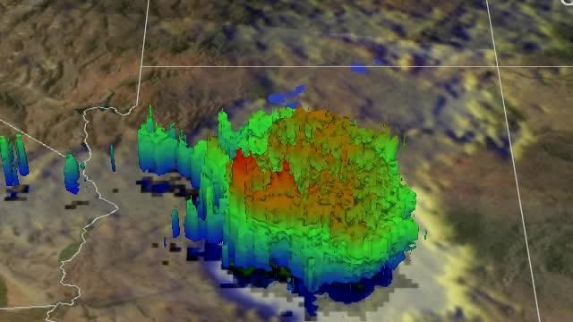
This simulated flyby of NASA's TRMM satellite on Sept. 8 saw rain falling at a rate of over 62 mm (2.4 inches) per hour in some downpours over Arizona. Some thunderstorm tops reached heights of 13.5 km (about 8.4 miles).
Image Credit:SSAI/NASA, Hal Pierce
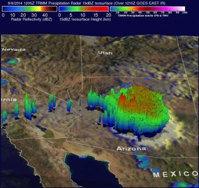
TRMM showed only a small amount of light to moderate rainfall was located around Norbert's center of circulation. However, the moisture moving in a huge counterclockwise circulation around Norbert's remnants was transported almost 1,000 miles away where it generated thunderstorms over Arizona. The TRMM image showed very heavy rainfall was being produced over the southwestern United States, including Arizona, southern California and southern Nevada.
Data from TRMM's Precipitation Radar (PR) instrument were used to create a 3-D image at NASA's Goddard Space Flight Center in Greenbelt, Maryland. The 3-D image showed that some showers located to the west of Norbert's center of circulation weren't very high.
This simulated flyby of NASA's TRMM satellite on Sept. 8 saw rain falling at a rate of over 62 mm (2.4 inches) per hour in some downpours over Arizona. Some thunderstorm tops reached heights of 13.5 km (about 8.4 miles).
(Photo Credit: Image : SSAI/NASA, Hal Pierce)
The TRMM satellite flew over the southwestern United States again on September 8 at 1205 UTC (5:05 a.m. PDT). At that time a cluster of intense thunderstorms was found in Arizona directly below the satellite. Rain was measured by the TRMM Precipitation Radar (PR) instrument falling at a rate of over 62 mm (2.4 inches) per hour in some downpours.
According to the National Weather Service, 3.29 inches of rain fell at the Phoenix airport breaking the day's record.
For over sixteen years the TRMM's Precipitation Radar (PR) has been providing three dimensional vertical profiles of precipitation from the surface of the earth to heights of about 12 miles (20 kilometers). The 3-D view showed that some thunderstorm tops reached heights of 13.5 km (about 8.4 miles).
On September 8, the moisture spreading northeastward from tropical storm Norbert caused flooding over inland areas of southern California. By September 9, that moisture generated the strong thunderstorms over Arizona that created widespread flooding led the Governor to declare a state of emergency in the state.
On Sept. 8 at 5:05 a.m. PDT the TRMM satellite saw a cluster of intense thunderstorms in Arizona directly below the satellite. Rain was falling at a rate of over 62 mm (2.4 inches) per hour in some downpours.
(Photo Credit: : SSAI/NASA, Hal Pierce)
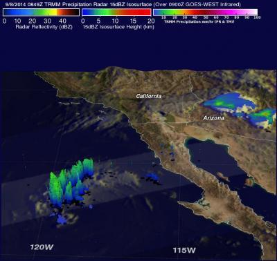
On Sept. 8, the TRMM satellite captured rainfall in former hurricane Norbert and the thunderstorms over Arizona generated by its moisture. Rainfall data was overlaid on a NOAA GOES-West satellite image of clouds.
(Photo Credit: : SSAI/NASA, Hal Pierce)
Source: NASA/Goddard Space Flight Center