Ice shelves, the floating extensions of the Antarctic and Greenland ice sheets, are not simply resting on the ocean waters: they rise, fall and bend with the tides. Ultimately, these oceanic motions impact the flow of ice coming from the glaciers that these ice shelves buttress. Ryan Walker and Christine Dow, researchers with the Cryospheric Sciences Laboratory at NASA Goddard Space Flight Center in Greenbelt, Maryland, recently spent more than a month doing fieldwork in Antarctica to study the influence of tidal movements on a small, little-studied ice shelf.
The NASA scientists worked with personnel from the Korea Polar Research Institute to install instruments on the Nansen Ice Shelf, a roughly 30-mile-long ice shelf sticking out from the coast of Antarctica's Victoria Land. The ice shelf is near the new South Korean Jang Bogo Station, where Walker and Dow stayed during their field campaign.
"Nansen is a smaller ice shelf but we're hoping that it's representative of many of the smaller ice shelves that ring Antarctica," Walker said. "We also hope that the techniques that we're testing out in this campaign can be used in the future on larger ice shelves."
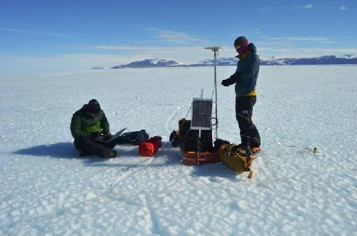
 NASA researcher Ryan Walker (left) downloads data from a GPS station he and Christine Dow installed on the Nansen Ice Shelf two weeks prior. Credit: Credits: NASA/Christine Dow
"Ice shelves are very important for holding back ice flow behind them because what they're essentially doing is acting as a plug; as soon as you remove them, there's nothing there preventing the ice mass from moving quickly down," Dow said. "It's a particular worry at the moment that the ice shelves around Antarctica are going to break up, and we're going to see an unprecedented speed-up in the ice coming from the center of the ice sheet."
Walker and Dow's instruments consisted of five GPS stations to measure the vertical and horizontal motion of the ice shelf, and two tilt meters, which are sensors that record subtle changes in the angle of the ice shelf as it bends with the ocean tides. They installed the GPS stations in the middle section of the ice shelf, where ice floats freely on ocean water, whereas the tilt meters were mounted in the grounding line area, or the boundary between the ice resting on land and the floating ice.
Despite being only a five-minute helicopter ride apart, the two field sites were very different.
"The ice shelf was all bare blue ice, with no snow on top of it and a fair amount of ridging. Those areas, because they're flat, they're very exposed - the wind coming out from the continent can be extremely strong in there and even on a relatively sunny day it can become very cold out there very quickly," Walker said. "The site where we put the tilt meters was in a small bay with mountain ridges on either side, with a pretty fair amount of snow. Absolutely the most beautiful place I've ever been to. We were completely sheltered from the winds by the mountains and it was a really sunny day - we wound up working with our jackets off because it was actually quite warm."
Both Walker and Dow are ice sheet modelers; they create computer simulations of the Antarctic and Greenland ice sheets to project how the ice will flow in the next decades and centuries and contribute to sea level rise. Walker will incorporate the GPS and tilt sensor measurements collected in Antarctica into his model of changes in ice shelf motion to further study how ocean tides both bend ice shelves vertically and affect the flow of ice toward the ocean.
"Examining how the ice shelf responds to tides helps us get at the dynamics of how the ice flows and we're hoping will help with future computer simulations, in particular of where the grounding zone is," Walker said. Pinpointing grounding lines is key to being able to observe how glaciers evolve, because changes in the grounding line can lead to rapid changes in ice flow.
The two researchers say that observing directly what an ice shelf looks like will help them with their modeling.
"If you're going to be making a model of the system, you want to know everything that you can about it," Walker said. "Actually seeing it gives you a bit more of a feeling for what sort of assumptions you can make, which things are essential and which things are oversimplifications."
Dow's work focuses on how lakes form underneath the ice sheet and how they impact the flow of the ice sheet. She joined Walker in his field trip primarily to help with installing the instruments, but since she is also working with South Korean researchers in modeling subglacial lakes in an area near the Nansen Ice Shelf, she also wanted to see the place firsthand.
This was Walker and Dow's first collaboration with the Korea Polar Research Institute, which they will continue over the next few years.
source: NASA/Goddard Space Flight Center