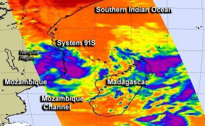
NASA's Aqua satellite captured infrared data on a developing area of tropical low pressure known as System 91S that was brushing the Nampala Province of Mozambique on January 28.
Nampula is a province in northern Mozambique and its eastern coast runs along the Mozambique Channel of the Southern Indian Ocean. When NASA's Aqua satellite passed over the Mozambique Channel on January 28 at 10:35 UTC/5:35 a.m. EST the Atmospheric Infrared Sounder instrument known as AIRS captured infrared data on the clouds associated with System 91S.
AIRS showed some of the thunderstorms surrounding the low-level center of circulation had high cloud tops, where temperatures exceeded -63F/-52C, a threshold that indicates strong storms and potentially heavy rainmakers. The Joint Typhoon Warning Center noted that animated multi-spectral satellite imagery showed that the low-level center was consolidating and that there were bands of thunderstorms wrapping into the center - a sign of strengthening.

NASA's Aqua satellite passed over the Mozambique Channel on January 28 at 10:35 UTC/5:35 a.m. EST and saw some of the thunderstorms had high cloud tops, where temperatures exceeded -63F/-52C (purple).
(Photo Credit: Image : NASA JPL, Ed Olsen)
System 91S was centered near 15.4 south and 41.6 east, about 810 nautical miles northeast of Maputo, Mozambique. Maximum sustained winds are near the threshold for depression status, currently as high as 30 knots. The low is over warm enough waters to support further development.
At 11 a.m. EST on January 28, Nacala, Mozambique, located on coastal Nampula, was reporting drizzle from the fringes of System 91S with thunderstorms expected at night and on January 29.
Forecasters at the Joint Typhoon Warning Center give System 91S a high chance for becoming a tropical depression in the next day as it tracks to the southwest in the Mozambique Channel.
Source: NASA/Goddard Space Flight Center