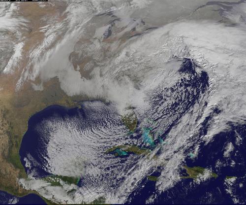
NASA satellite imagery captured the size of the massive winter storm that continued to pummel the U.S. East Coast early on Jan. 23, 2016.
NASA-NOAA's Suomi NPP satellite passed over the large low pressure area on Jan. 22, 2016 at 1855 UTC (1:55 p.m. EST) and the VIIRS instrument captured an image of the massive storm that stretched from New England south to Florida. At the time of the image, the low pressure center was in the southeastern U.S. and has since moved northeast and off the coast of the Carolinas as the storm continued to intensify and bring heavy snow and blizzard conditions to the Baltimore/Washington area. By 1200 UTC (7 a.m. EST) the low pressure center was over the Delmarva Peninsula (Delaware/Maryland/Virginia).
At 5:56 a.m. EST on Jan. 23, 2016 the National Weather Service (NWS) Weather Prediction Center in College Park, Maryland issued their short range forecast discussion with the title "Major to historic winter storm will impact the middle Atlantic to southern New England into Sunday."
 This visible image of the major winter storm was taken from NOAA's GOES-East satellite on Saturday, Jan. 23, 2016 at 1437 UTC (9:37 a.m. EST) as the Baltimore/Washington corridor was under a blizzard warning. Credit: Credits: NASA/NOAA GOES Project
NWS said "A powerful low pressure system will bring heavy snow and blizzard conditions from the Middle Atlantic Region all the way through southern New England. The heaviest snow is expected to fall over the Middle Atlantic Region including the Washington DC and Baltimore metro areas west to the Blue Ridge Mountains. In addition, moderate coastal flooding is expected. The storm will taper off by Sunday."
By 6 a.m. EST, many locations across Maryland and Washington D.C. reported accumulations already 1 foot, with more expected. An additional 8 to 15 inches is forecast along the D.C. to Long Island corridor for the duration of the storm.
A visible image of the major winter storm was taken from NOAA's GOES-East satellite on Saturday, January 23, 2016 at 1437 UTC (9:37 a.m. EST) as the Baltimore/Washington corridor was under a blizzard warning. Compared to the earlier image from the Suomi NPP satellite, the low pressure center had moved further northeast and was over the Delmarva Peninsula.
Although the precipitation associated with the system had departed Florida, the northern part of the state was dealing with winds and cold. On Saturday, Jan. 23, 2016 at 9 a.m. EST at Daytona Beach, Florida, a Freeze Warning was in effect until Jan. 24, 2016 8:00 a.m. EST and a Wind Advisory was in effect until 7 p.m. EST on Jan. 23 as wind chills in the teens will be possible at night. Wind advisories stretched as far south as Miami.
Winter Storm Warnings and a handful of Blizzard Warnings remain in effect from the Southeast to the Northeast. By Sunday morning, January 24, 2016 the low pressure storm center is forecast to move further offshore into the North Atlantic Ocean. For updated forecasts from the NWS, visit: http://www.weather.gov.
NASA-NOAA's Suomi NPP satellite passed over the large low pressure area on Jan. 22, 2016 at 1855 UTC (1:55 p.m. EST) and the VIIRS instrument captured an image of the massive storm that stretched from New England south to Florida. At the time of the image, the low pressure center was in the southeastern U.S. and has since moved northeast and off the coast of the Carolinas as the storm continued to intensify and bring heavy snow and blizzard conditions to the Baltimore/Washington area. By 1200 UTC (7 a.m. EST) the low pressure center was over the Delmarva Peninsula (Delaware/Maryland/Virginia).
At 5:56 a.m. EST on Jan. 23, 2016 the National Weather Service (NWS) Weather Prediction Center in College Park, Maryland issued their short range forecast discussion with the title "Major to historic winter storm will impact the middle Atlantic to southern New England into Sunday."
NWS said "A powerful low pressure system will bring heavy snow and blizzard conditions from the Middle Atlantic Region all the way through southern New England. The heaviest snow is expected to fall over the Middle Atlantic Region including the Washington DC and Baltimore metro areas west to the Blue Ridge Mountains. In addition, moderate coastal flooding is expected. The storm will taper off by Sunday."
By 6 a.m. EST, many locations across Maryland and Washington D.C. reported accumulations already 1 foot, with more expected. An additional 8 to 15 inches is forecast along the D.C. to Long Island corridor for the duration of the storm.
A visible image of the major winter storm was taken from NOAA's GOES-East satellite on Saturday, Jan. 23, 2016 at 1437 UTC (9:37 a.m. EST) as the Baltimore/Washington corridor was under a blizzard warning. Compared to the earlier image from the Suomi NPP satellite, the low pressure center had moved further northeast and was over the Delmarva Peninsula.
Although the precipitation associated with the system had departed Florida, the northern part of the state was dealing with winds and cold. On Saturday, Jan. 23, 2016 at 9 a.m. EST at Daytona Beach, Florida, a Freeze Warning was in effect until Jan. 24, 2016 8:00 a.m. EST and a Wind Advisory was in effect until 7 p.m. EST on Jan. 23 as wind chills in the teens will be possible at night. Wind advisories stretched as far south as Miami.
Winter Storm Warnings and a handful of Blizzard Warnings remain in effect from the Southeast to the Northeast. By Sunday morning, January 24, the low pressure storm center is forecast to move further offshore into the North Atlantic Ocean. For updated forecasts from the NWS, visit: http://www.weather.gov.
source: NASA/Goddard Space Flight Center