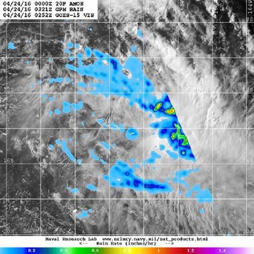
On Sunday, April 24, 2016 Tropical Cyclone Amos ran into increasing wind shear that tore the storm apart. A composite satellite image from two satellites showed waning precipitation and lack of thunderstorm development from wind shear.
Visible imagery from NOAA's GOES-West on April 24, 2016 at 0252 UTC (April 23, 2016 at 10:52 p.m. EDT) and precipitation data from NASA and the Japan Aerospace Exploration Agency's Global Precipitation Measurement (GPM) Mission on April 24, 2016 at 0321 UTC (April. 23, 2016 at 11:21 a.m. EDT) was combined at the U.S. Naval Research Laboratory in Washington, D.C. The imagery showed the storm had elongated because of the wind shear. Heaviest rainfall, at about 1 inch (25 mm) per hour appeared in the northwestern quadrant of the storm on GPM radar.
By 1500 UTC (11 a.m. EDT) on April 24, 2016 Amos moved past Pago Pago and continued on an easterly track at 7 knots (8 mph/12.9 kph) while weakening. At that time, Amos' maximum sustained winds were near 40 knots (46 mph/74 kph) and it was weakening quickly.
 This composite visible image from NOAA's GOES-West and NASA/JAXA's GPM satellite shows wind shear elongated Tropical Cyclone Amos. Credit: Credits: NRL/NASA/JAXA/NOAA
By the end of the day, Amos had dissipated in the Southern Pacific Ocean.
NASA's Goddard Space Flight Center
source: NASA/Goddard Space Flight Center