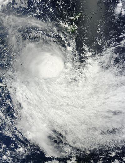
Tropical Cyclone Lusi is battling vertical wind shear that has been pushing the bulk of precipitation away from its center. NASA's Terra satellite captured an image of the storm that showed the strongest thunderstorms were being pushed away from the center.
On March 12 at 22:25 UTC/6:25 p.m. EDT, The Moderate Resolution Imaging Spectroradiometer or MODIS instrument that flies aboard NASA's Terra satellite captured a visible image of Tropical Cyclone Lusi in the South Pacific Ocean. The image showed a concentration of thunderstorms just south of the center of circulation.
On March 13 at 0900 UTC Tropical Cyclone Lusi was at hurricane-force with maximum sustained winds near 65 knots/74.8 mph/120.4 kph. Lusi was centered near 24.2 south latitude and 173.9 east longitude, about 406 nautical miles/467.2 miles/751.9 km southwest of Suva, Fiji. Lusi is moving to the southeast at 17 knots/19.5 mph/ 31.4 kph.
The Joint Typhoon Warning Center noted that animated multispectral satellite imagery showed Lusi started to weaken as the deep convection has been pushed south of the center from vertical wind shear. The storm's low-level center still appears to be tightly wrapped, however.

On March 12 at 22:25 UTC/6:25 p.m. EDT, NASA's Terra satellite captured this image of Tropical Cyclone Lusi in the South Pacific Ocean.
(Photo Credit: Image : NASA Goddard MODIS Rapid Response Team)
Lusi is expected to track south for the next several days into cooler waters which will continue to weaken it, and help transition it into an extra-tropical storm.
The New Zealand Meteorological Service has already issued a watch for heavy rains from Lusi. Lusi is expected to move just west of the North Island on Saturday, March 15 before crossing the South Island late Sunday, March 16. The Met Service expects rain and easterly winds to start affecting northern New Zealand late in the day on Friday, March 14 and then expand.
According to the Watch, heavy rain can be expected in Northland, Auckland and the Coromandel Peninsula late Friday or Saturday, and for Bay of Plenty and northern Gisborne on Saturday. For updated watches and warnings, visit: http://www.metservice.com.
Source: NASA/Goddard Space Flight Center